IMAGES TAKEN NEAR TO
Newbury Gardens, UPMINSTER, RM14 2PT
Introduction
This page details the photographs taken nearby to Newbury Gardens, RM14 2PT by members of the Geograph project.
The Geograph project started in 2005 with the aim of publishing, organising and preserving representative images for every square kilometre of Great Britain, Ireland and the Isle of Man.

There are currently over 7.5m images from over14,400 individuals and you can help contribute to the project by visiting https://www.geograph.org.uk
Image Map
Images are licensed for reuse under creativecommons.org/licenses/by-sa/2.0
Notes
- Clicking on the map will re-center to the selected point.
- The higher the marker number, the further away the image location is from the centre of the postcode.
Image Listing (44 Images Found)
Images are licensed for reuse under creativecommons.org/licenses/by-sa/2.0
Image
Details
Distance
1
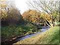
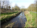
Ingrebourne River south of Upminster
The Ingrebourne rises near Brentwood and enters the Thames at Rainham having provided a rural corridor between the London suburbs of Emerson Park, Cranham, Upminster and Hornchurch en route. Taken from the London Loop footpath.
Image: © David Kemp
Taken: 7 Nov 2008
0.09 miles
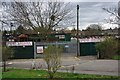
2
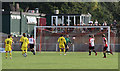
Football at Bridge Avenue Stadium
Wingate & Finchley FC, in yellow, play away against Hornchurch FC. Behind the goal, spectators take advantage of a glorious autumn day to sit and enjoy a beer in the garden of the bar complex. The bar is housed in the green building behind.
Image: © Martin Addison
Taken: 1 Oct 2011
0.12 miles
3
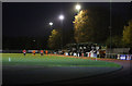
West Stand at The Bridge Avenue Stadium
The West Stand as seen from the north end of the ground during a match between Hornchurch and Wingate & Finchley. The Urchins (Hornchurch) in the red and white striped shirts ran out 3-0 winners over the visitors.
Image: © Martin Addison
Taken: 30 Nov 2013
0.14 miles
4
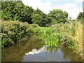
Ingrebourne River in Upminster
The Ingrebourne rises near Brentwood and flows into the Thames at Rainham, a distance of about 27 miles or about 43 kilometres.
Image: © Nigel Cox
Taken: 28 Jul 2010
0.14 miles
5
Hornchurch Stadium
Hornchurch Stadium http://www.runtrackdir.com/details.asp?track=hornchurch is home to Hornchurch AFC http://www.afchornchurch.com/ and Havering Mayesbrook Athletic Club http://www.havering-mayesbrook.org/
Image: © Glyn Baker
Taken: 2 Apr 2010
0.15 miles
6
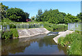
Upminster Gauging Station
The Environment Agency's gauging weir on the River Ingrebourne in Gaynes Park.
Station spec. on http://www.environment-agency.gov.uk/hiflows/station.aspx?37018
Image: © Des Blenkinsopp
Taken: 4 Jun 2013
0.15 miles
7
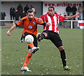
Challenging For The Ball
Wingate & Finchley and Hornchurch players challenge for the ball. The player on the right is in 'The Urchins' home strip of red and white striped shirt and black shorts. The Wingate & Finchley player is wearing the 2013/14 away strip of orange shirt and black shorts. The home side won the game 3-0.
Image: © Martin Addison
Taken: 30 Nov 2013
0.16 miles
8
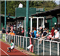
Bridge Avenue Stadium
Football fans enjoy a match between Hornchurch FC and Wingate & Finchley FC on a glorious autumn afternoon. Hornchurch FC are known as The Urchins.
Image: © Martin Addison
Taken: 1 Oct 2011
0.17 miles
9
London LOOP alongside the River Ingrebourne
Hornchurch Country Park is the former site of Sutton's Farm airfield which opened on 3rd October 1915, from which biplanes of the Royal Flying Corps defended London in the First World War. Lieutenant William Leefe-Robinson took off from the airfield on the night of 2nd September 1916 and shot down the first German Zeppelin airship to crash over British soil. For this action he received the Victoria Cross. The airfield closed after the First World War, but the land was requisitioned in 1923 because of the expansion of the RAF and the airfield opened as a much larger fighter station, RAF Hornchurch. Fighter squadrons from Hornchurch were prominent in the Battle of France over Dunkirk and the Battle of Britain and it became one of the most famous Spitfire stations in Fighter Command. The airfield was ideally located in bomb alley to cover both London and the Thames corridor from German air attacks.
After the War it became the RAF's Aircrew Selection Centre during the 1950s. In 1962 the airfield closed and the site was sold for gravel extraction. In 1980, following ground restoration, including in-filling with landfill, the Greater London Council carried out a massive landscaping project to create Hornchurch Country Park. The road names of the local airfield housing estate commemorate the airfield and its pilots.
A new visitor centre was opened on 3rd October 2015, the 100th anniversary of the original airfield. It includes exhibition space and a cafe and has been named Ingrebourne Valley Visitor Centre as it provides a focal point and gateway to the wider landscape of the Ingrebourne Valley. It is a joint venture between Essex Wildlife Trust and the London Borough of Havering.
The London LOOP follows the entire length of Hornchurch Country Park and the Ingrebourne Valley from Upminster Bridge. This is after crossing Hacton Lane on the way to Upminster Bridge.
The Ingrebourne Valley, in which Hornchurch Country Park is situated, comprises 650 acres of various habitats, including river, open water, marsh, grassland, reedbeds and woodland. It is a Local Nature Reserve and a SSSI.
See http://data.wildlifetrusts.org/sites/default/files/Hornchurch%20Country%20Park%20Info%20&%20Map.pdf for more information about Hornchurch Country Park.
Image: © Marathon
Taken: 13 Mar 2017
0.18 miles
10
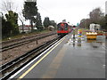
Upminster Bridge Underground station
The London, Tilbury & Southend Railway opened its line from Forest Gate via Barking and Dagenham Dock to Tilbury in 1854. In 1858 the company opened a cut off between Bow and Barking.
What is now the C2C line was opened in 1885 by the London, Tilbury & Southend Railway between Barking and Upminster, and a station was opened at Dagenham (East) the same year. No further stations opened on the line until Gale Street Halt (now Becontree) in 1926, followed by Hornchurch, Heathway (later renamed Dagenham Heathway from 1st May 1949) and Upney on 12th September 1932. On the same date as these stations opened in 1932, the District line was extended over new tracks alongside the existing line between Barking and Upminster. The present C2C line therefore dates from 1885 and the present District line from 1932. Upminster Bridge station was opened on 17th December 1934.
This view from the end of the up platform looks along the up District line as a Richmond bound train leaves. The two C2C lines are to the left. Hornchurch is the next station in this direction. This was a very wet day with frequent showers.
Image: © Marathon
Taken: 9 Mar 2016
0.20 miles