IMAGES TAKEN NEAR TO
Hacton Lane, UPMINSTER, RM14 2NL
Introduction
This page details the photographs taken nearby to Hacton Lane, RM14 2NL by members of the Geograph project.
The Geograph project started in 2005 with the aim of publishing, organising and preserving representative images for every square kilometre of Great Britain, Ireland and the Isle of Man.

There are currently over 7.5m images from over14,400 individuals and you can help contribute to the project by visiting https://www.geograph.org.uk
Image Map
Images are licensed for reuse under creativecommons.org/licenses/by-sa/2.0
Notes
- Clicking on the map will re-center to the selected point.
- The higher the marker number, the further away the image location is from the centre of the postcode.
Image Listing (51 Images Found)
Images are licensed for reuse under creativecommons.org/licenses/by-sa/2.0
Image
Details
Distance
2
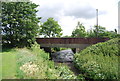
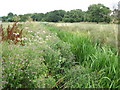
Ingrebourne River in Upminster
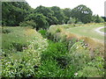
This is the reed-choked Ingrebourne viewed looking downstream from Hacton Bridge. A large growth of the invasive Himalayan Balsam (impatiens glandulifera) is visible on the bank to the left. The Ingrebourne rises near Brentwood and flows into the Thames at Rainham, a distance of about 27 miles or about 43 kilometres.
Image: © Nigel Cox
Taken: 28 Jul 2010
0.05 miles
7
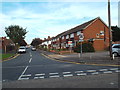
Alder Avenue, near Upminster
Alder Avenue is a residential road on the outer fringes of east London.
Image: © Malc McDonald
Taken: 28 Aug 2017
0.07 miles
9
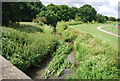
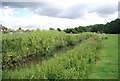
Ingrebourne River in Upminster
This is the reed-choked Ingrebourne viewed looking upstream from near Hacton Bridge.
Image: © Nigel Cox
Taken: 28 Jul 2010
0.08 miles
10
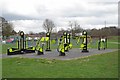
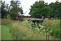
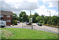
Grownups Allowed!
Havering Council has provided playthings so Mums and Dads don’t feel left out when the kiddies are playing on their rides! These were on the edge the Ingrebourne Valley local nature reserve near Hacton Lane.
Image: © Glyn Baker
Taken: 2 Apr 2010
0.08 miles