IMAGES TAKEN NEAR TO
Parkland Avenue, UPMINSTER, RM14 2EX
Introduction
This page details the photographs taken nearby to Parkland Avenue, RM14 2EX by members of the Geograph project.
The Geograph project started in 2005 with the aim of publishing, organising and preserving representative images for every square kilometre of Great Britain, Ireland and the Isle of Man.

There are currently over 7.5m images from over14,400 individuals and you can help contribute to the project by visiting https://www.geograph.org.uk
Image Map
Images are licensed for reuse under creativecommons.org/licenses/by-sa/2.0
Notes
- Clicking on the map will re-center to the selected point.
- The higher the marker number, the further away the image location is from the centre of the postcode.
Image Listing (33 Images Found)
Images are licensed for reuse under creativecommons.org/licenses/by-sa/2.0
Image
Details
Distance
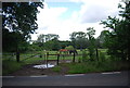
1
Photobombed in Parklands
I was framing up for an artistic shot of the park, lake and bridge when I was photo-bombed! I have resisted the temptation to change one vowel!
Image: © Glyn Baker
Taken: 26 Mar 2020
0.04 miles
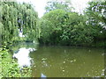
2
Parklands, Corbets Tey
This is what remains of the parkland which surrounded the manor house at Gaynes, which was eventually demolished in 1929. The Parkland is open to the public.
This section runs adjacent to a lake with an ornamental bridge http://www.geograph.org.uk/photo/747272.
Image: © Roger Jones
Taken: 14 Sep 2013
0.07 miles
3
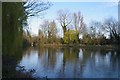
The Serpentine Lake in Parklands
Part of a green lung in Corbets Tey
Image: © Glyn Baker
Taken: 26 Mar 2020
0.07 miles
4
Parklands Lake
This serpentine lake is in Parklands Corbets Tey http://www.havering.gov.uk/index.aspx?articleid=4472
Image: © Glyn Baker
Taken: 30 Mar 2008
0.07 miles
5
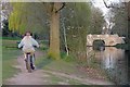
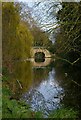
Bridge in Parklands
I have a feeling there has been some remedial work since my last shot of the bridge
see Image You can find out a lot more by going to
Image N.B the two couples talking on the bridge were at least 2m apart as per government instructions.
Image: © Glyn Baker
Taken: 26 Mar 2020
0.09 miles
6
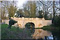
Historic footbridge across the lake in Parklands Open Space
Parklands Open Space was originally part of Gaynes (or Engaynes) Manor. The origin of the Gaynes Estate dates back to Roman Britain and in its hey-day in the Middle Ages, comprised about 1500 acres covering most of the south half of Upminster. From 1817 onwards, parts of the estate, by then c.750 acres, were sold off to various private owners and eventually in 1929 the estate was sold for building development. The late 18th century bridge seen here is attributed to designer/architect James Paine (whose other works include Thorndon Hall and the grand stables at Chatsworth House). It is Grade II Listed and has been recently restored after being allowed to fall into disrepair so that it had been on English Heritage's 'At Risk Register'. The lake and Parklands Bridge remain, together with a grass walk along the northern bank, which were acquired by Hornchurch Urban District Council as public open space.
A very full history is provided by the Friends of Uplands, Upminster - http://www.friendsofparklands.org.uk/history.html
Image: © Marathon
Taken: 24 May 2017
0.10 miles
7
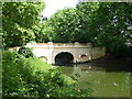
Parklands Park bridge, Upminster
Grade II listed.
C18 bridge. Stuccoed over brick. Large semi-circular central arch with
stepped keystone, and 2 smaller blocked side arches of similar form. Four
piers originally with raised rectangular panels. Balustraded parapet with
panelled standards and segmental cap-stones. Curved approach walls.
Image: © Paul Jones
Taken: 20 Nov 2020
0.11 miles
8
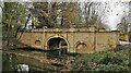
The lake in Parklands Open Space
Parklands Open Space was originally part of Gaynes (or Engaynes) Manor. The origin of the Gaynes Estate dates back to Roman Britain and in its hey-day in the Middle Ages, comprised about 1500 acres covering most of the south half of Upminster. From 1817 onwards, parts of the estate, by then c.750 acres, were sold off to various private owners and eventually in 1929 the estate was sold for building development. The late 18th century bridge is attributed to designer/architect James Paine (whose other works include Thorndon Hall and the grand stables at Chatsworth House). It is Grade II Listed and has been recently restored after being allowed to fall into disrepair so that it had been on English Heritage's 'At Risk Register'. The lake and Parklands Bridge remain, together with a grass walk along the northern bank, which were acquired by Hornchurch Urban District Council as public open space.
A very full history is provided by the Friends of Uplands, Upminster - http://www.friendsofparklands.org.uk/history.html
Image: © Marathon
Taken: 24 May 2017
0.16 miles
9
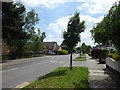
Corbets Tey Road
This is on the corner of Tawny Avenue looking in the direction of Corbets Tey.
Image: © Marathon
Taken: 24 May 2017
0.17 miles