IMAGES TAKEN NEAR TO
Corbets Avenue, UPMINSTER, RM14 2EQ
Introduction
This page details the photographs taken nearby to Corbets Avenue, RM14 2EQ by members of the Geograph project.
The Geograph project started in 2005 with the aim of publishing, organising and preserving representative images for every square kilometre of Great Britain, Ireland and the Isle of Man.

There are currently over 7.5m images from over14,400 individuals and you can help contribute to the project by visiting https://www.geograph.org.uk
Image Map
Images are licensed for reuse under creativecommons.org/licenses/by-sa/2.0
Notes
- Clicking on the map will re-center to the selected point.
- The higher the marker number, the further away the image location is from the centre of the postcode.
Image Listing (18 Images Found)
Images are licensed for reuse under creativecommons.org/licenses/by-sa/2.0
Image
Details
Distance
1
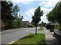
Corbets Tey Road
This is on the corner of Tawny Avenue looking in the direction of Corbets Tey.
Image: © Marathon
Taken: 24 May 2017
0.10 miles
2
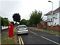
Tawny Avenue, Upminster
Showing position of Postbox No. RM14 313.
Image: © JThomas
Taken: 23 Aug 2022
0.11 miles
3
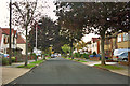
Tawny Avenue, Upminster
A product of the suburban spread of Upminster over the parkland of Gaynes Park between the wars. It was a slow development, even up to at least 1950 there were many plots not built on, and the road was unmade*. Oddly, on the first Ordnance Survey large scale map to show the road, it was called 'Dawns Avenue' - a misread developer's plan?
* I know because I was there!
Image: © Robin Webster
Taken: 18 Sep 2011
0.11 miles
4
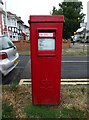
Elizabeth II postbox on Tawny Avenue, Upminster
Postbox No. RM14 313.
Image: © JThomas
Taken: 23 Aug 2022
0.11 miles
5
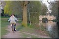
Photobombed in Parklands
I was framing up for an artistic shot of the park, lake and bridge when I was photo-bombed! I have resisted the temptation to change one vowel!
Image: © Glyn Baker
Taken: 26 Mar 2020
0.14 miles
6
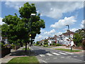
Corbets Tey Road
This is on the corner of Tawny Avenue looking in the direction of Upminster.
Image: © Marathon
Taken: 24 May 2017
0.16 miles
7
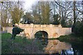
Bridge in Parklands
I have a feeling there has been some remedial work since my last shot of the bridge
see Image You can find out a lot more by going to
Image N.B the two couples talking on the bridge were at least 2m apart as per government instructions.
Image: © Glyn Baker
Taken: 26 Mar 2020
0.16 miles
8
Parklands Lake
This serpentine lake is in Parklands Corbets Tey http://www.havering.gov.uk/index.aspx?articleid=4472
Image: © Glyn Baker
Taken: 30 Mar 2008
0.16 miles
9
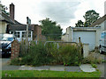
Blocked off footpath, The Grove
This was disappointing - the path between houses featured remains of an old bridge which always intrigued me as a boy. I was hoping to have another look. It must have been partly ornamental, in the grounds of the estate that was here before the housing development.
Image: © Robin Webster
Taken: 18 Sep 2011
0.16 miles
10
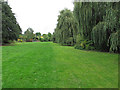
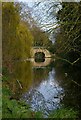
Parklands, Corbets Tey
This is what remains of the parkland which surrounded the manor house at Gaynes, which was eventually demolished in 1929. The Parkland is open to the public.
This section runs adjacent to a lake with an ornamental bridge http://www.geograph.org.uk/photo/747272.
Image: © Roger Jones
Taken: 14 Sep 2013
0.16 miles