IMAGES TAKEN NEAR TO
Palliser Drive, RAINHAM, RM13 9TG
Introduction
This page details the photographs taken nearby to Palliser Drive, RM13 9TG by members of the Geograph project.
The Geograph project started in 2005 with the aim of publishing, organising and preserving representative images for every square kilometre of Great Britain, Ireland and the Isle of Man.

There are currently over 7.5m images from over14,400 individuals and you can help contribute to the project by visiting https://www.geograph.org.uk
Image Map
Images are licensed for reuse under creativecommons.org/licenses/by-sa/2.0
Notes
- Clicking on the map will re-center to the selected point.
- The higher the marker number, the further away the image location is from the centre of the postcode.
Image Listing (165 Images Found)
Images are licensed for reuse under creativecommons.org/licenses/by-sa/2.0
Image
Details
Distance

2
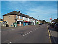
Wennington Road, Rainham
Wennington Road in Rainham, on the outer fringe of east London.
Image: © Malc McDonald
Taken: 28 Aug 2017
0.07 miles
3
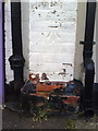
Benchmark on #121 Wennington Road
Ordnance Survey cut mark benchmark described on the Bench Mark Database at http://www.bench-marks.org.uk/bm36093
Image: © Roger Templeman
Taken: 21 Nov 2010
0.07 miles
4
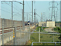
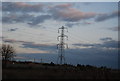
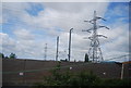
A lot of galvanized steel (and some aluminium)
Pylons and railway catenary supports contribute most, but there is a fair amount of fencing and railing also. The near pylon is a rare case of an ordinary design at a change of direction. It is probable the slight change of direction resulted from alterations to avoid the CTRL railway works - there seems no reason why it would have been part of the original route.
Image: © Robin Webster
Taken: 24 Apr 2011
0.09 miles
8
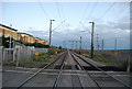
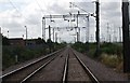
High Speed 1 towards West Thurrock
As seen from Image
This railway carries the Channel Tunnel Railway from Stratford towards Ebbsfleet (in Kent). It heads towards West Thurrock where it heads into a tunnel under the River Thames.
On the left, the local railway line between Rainham and Purfleet can just be seen.
Image: © David Anstiss
Taken: 7 Nov 2012
0.11 miles
9
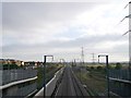
Engineering plant on HS1 before opening
The HS1 high speed line from London to Ashford was at this time structurally complete but still being finished off before opening. The photo is taken from the footbridge at Rainham station.
Image: © Stephen Craven
Taken: 19 Jun 2006
0.12 miles
10
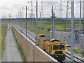
Pylon by the Channel Tunnel Rail Link, Rainham
Image: © N Chadwick
Taken: 18 Jun 2011
0.12 miles