IMAGES TAKEN NEAR TO
The Robins, Lake Avenue, RAINHAM, RM13 9SZ
Introduction
This page details the photographs taken nearby to The Robins, Lake Avenue, RM13 9SZ by members of the Geograph project.
The Geograph project started in 2005 with the aim of publishing, organising and preserving representative images for every square kilometre of Great Britain, Ireland and the Isle of Man.

There are currently over 7.5m images from over14,400 individuals and you can help contribute to the project by visiting https://www.geograph.org.uk
Image Map (Loading...)


Getting Data...Please wait
Leaflet Map data © OpenStreetMap
Images are licensed for reuse under creativecommons.org/licenses/by-sa/2.0
Notes
- Clicking on the map will re-center to the selected point.
- The higher the marker number, the further away the image location is from the centre of the postcode.
Image Listing (16 Images Found)
Images are licensed for reuse under creativecommons.org/licenses/by-sa/2.0
Image
Details
Distance
3
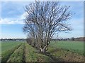
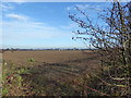
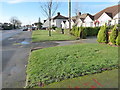
The edge of the Green Belt
Just to the east of the Abbey Wood Estate is open countryside as seen here. It is surprising how quickly one is out into open country although no doubt if it was not for the Green Belt housing would have covered these fields. This footpath leads from Berwick Pond Road to the Abbey Wood Estate ahead.
Image: © Marathon
Taken: 14 Dec 2016
0.16 miles
4
The edge of the Green Belt
Just to the right of Greenacres Close on the Abbey Wood Estate is open countryside - see http://www.geograph.org.uk/photo/5226127 It is surprising how quickly one is out into open country although no doubt if it was not for the Green Belt housing would have continued to the east from here.
Image: © Marathon
Taken: 14 Dec 2016
0.17 miles
5
The edge of the Green Belt
Just to the west of this field is the Abbey Wood Estate. It is surprising how quickly one is out into open country although no doubt if it was not for the Green Belt these fields would have been built on by now.
Image: © Marathon
Taken: 14 Dec 2016
0.18 miles
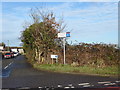
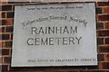
6
Jewish Cemetery Rainham
The cemetery is located on Upminster Rd North. See inside at Image
Image: © Glyn Baker
Taken: 16 Aug 2005
0.20 miles
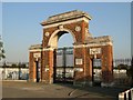
7
Cemetery Plaque
The plaque on the gateway to Image
Image: © Glyn Baker
Taken: 26 Jul 2009
0.21 miles
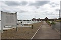
8
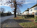
Upminster Road North
This is on the edge of the Abbey Wood Estate and just before the Green Belt is reached.
Image: © Marathon
Taken: 14 Dec 2016
0.22 miles
9
Upminster Road North
This is on the edge of the Abbey Wood Estate and just before the Green Belt is reached.
Image: © Marathon
Taken: 14 Dec 2016
0.22 miles
10
"House of the Living"
This is the Image in Rainham. Compared to secular municipal burial grounds or the classic English country churchyard the lack of vegetation makes the Jewish way of death seem rather stark to my non-religious eyes.
Image: © Glyn Baker
Taken: 26 Jul 2009
0.22 miles