IMAGES TAKEN NEAR TO
Beechwood Gardens, RAINHAM, RM13 9HU
Introduction
This page details the photographs taken nearby to Beechwood Gardens, RM13 9HU by members of the Geograph project.
The Geograph project started in 2005 with the aim of publishing, organising and preserving representative images for every square kilometre of Great Britain, Ireland and the Isle of Man.

There are currently over 7.5m images from over14,400 individuals and you can help contribute to the project by visiting https://www.geograph.org.uk
Image Map
Images are licensed for reuse under creativecommons.org/licenses/by-sa/2.0
Notes
- Clicking on the map will re-center to the selected point.
- The higher the marker number, the further away the image location is from the centre of the postcode.
Image Listing (13 Images Found)
Images are licensed for reuse under creativecommons.org/licenses/by-sa/2.0
Image
Details
Distance
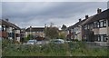
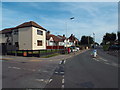
2
New Build in Brookway
Looking back towards the Wennington Road. 10 1/10ths blue sky and no jet traces. I have not seen that often since since Eyjafjallajökull blew its top. A tiny plus for CV-19.
Image: © Glyn Baker
Taken: 4 Apr 2020
0.14 miles
3
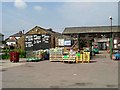
Knight's Farm
This is Knights Farm’s retail outlet. Inside the old farm buildings there is a veritable mini supermarket selling all kinds of household requirements and not just food. The corn is locally grown the cornfield is less than a km away.
Image: © Glyn Baker
Taken: 5 Sep 2005
0.14 miles
4
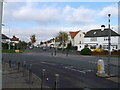
Road junction on Wennington Road
The main road leads from Wennington left towards Rainham.
Lambs Lane South leads right and Ingrebourne Road leads straight on.
Image: © David Anstiss
Taken: 7 Nov 2012
0.15 miles
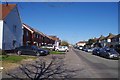
5
Wennington Road, Rainham
Wennington Road heading out of Rainham, on the outer fringe of east London.
Image: © Malc McDonald
Taken: 28 Aug 2017
0.15 miles
6
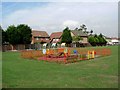
Beware of Toddlers
The children’s play area on a recreation ground in Rainham. The general public are protected from marauding nippers by the sturdy fence!
Image: © Glyn Baker
Taken: 5 Sep 2005
0.20 miles
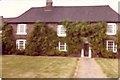
7
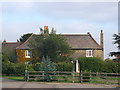
South Hall Farmhouse, Rainham
Grade II listed building as seen from Wennington Road.
See http://www.britishlistedbuildings.co.uk/en-201670-south-hall-farmhouse-greater-london-auth for more details about the house.
Image: © David Anstiss
Taken: 7 Nov 2012
0.21 miles
8
Wasteland by the Rail Tracks
No land is ever truly wasted as wildlife will always take advantage. Looking across the C2C line towards the Channel Tunnel Rail Link.
Image: © Glyn Baker
Taken: 4 Apr 2020
0.21 miles
9
Southall Farm House
View of house from Wennington Road,bduring the Second World a German bomb dropped to right and rear of the house, the farmer at that time named Gunnery let the crater; about 25 feet in diameter, fill with water and stocked it with Carp.
Image: © Gordon BEACH
Taken: Unknown
0.22 miles
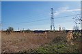
10

Pylons
Taken from the footbridge that crosses the c2c line from London to Grays (seen here) and the Channel Tunnel Rail Link which lies to the right.
Image: © David Kemp
Taken: 23 Oct 2008
0.23 miles