IMAGES TAKEN NEAR TO
East Hall Lane, RAINHAM, RM13 9DS
Introduction
This page details the photographs taken nearby to East Hall Lane, RM13 9DS by members of the Geograph project.
The Geograph project started in 2005 with the aim of publishing, organising and preserving representative images for every square kilometre of Great Britain, Ireland and the Isle of Man.

There are currently over 7.5m images from over14,400 individuals and you can help contribute to the project by visiting https://www.geograph.org.uk
Image Map
Images are licensed for reuse under creativecommons.org/licenses/by-sa/2.0
Notes
- Clicking on the map will re-center to the selected point.
- The higher the marker number, the further away the image location is from the centre of the postcode.
Image Listing (7 Images Found)
Images are licensed for reuse under creativecommons.org/licenses/by-sa/2.0
Image
Details
Distance
1
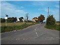
East Hall Lane, near Wennington
East Hall Lane, near Wennington on the outer fringe of east London.
Image: © Malc McDonald
Taken: 28 Aug 2017
0.06 miles
2
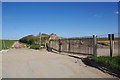
East Hall Lane and Wennington Quarry
The lane is now blocked off at both ends see Image N.B note the lack of jet traces due to CV-19.
Image: © Glyn Baker
Taken: 4 Apr 2020
0.10 miles
3
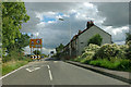
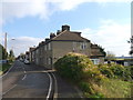
Traffic calming past New Cottages
An isolated row of houses between Rainham and Wennington.
Image: © Robin Webster
Taken: 18 Sep 2011
0.13 miles
4
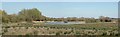
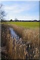
"New" Wetland by Wennington Road
Until 2012 I drove past here every working day on the way to Rainham Station. In those days this was well drained arable land. I assume the wildlife zone was created as part of the planning gain
for Image
Image: © Glyn Baker
Taken: 4 Apr 2020
0.15 miles
5
Wennington Road and Wennington Cottages
Laudry Cottages are seen first.
Wennington Road leads through the small village towards the A1306.
Image: © David Anstiss
Taken: 7 Nov 2012
0.21 miles
6
Common Water Course From Southall Bridge
Looking down stream
Image: © Glyn Baker
Taken: 4 Apr 2020
0.23 miles
7
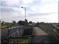
Southall Bridge
On Wennington Road leading from Rainham towards Wennington.
It passes over Common Watercourse (river/ field drain).
Image: © David Anstiss
Taken: 7 Nov 2012
0.23 miles