IMAGES TAKEN NEAR TO
Victory Road, RAINHAM, RM13 7RS
Introduction
This page details the photographs taken nearby to Victory Road, RM13 7RS by members of the Geograph project.
The Geograph project started in 2005 with the aim of publishing, organising and preserving representative images for every square kilometre of Great Britain, Ireland and the Isle of Man.

There are currently over 7.5m images from over14,400 individuals and you can help contribute to the project by visiting https://www.geograph.org.uk
Image Map (Loading...)


Getting Data...Please wait
Leaflet Map data © OpenStreetMap
Images are licensed for reuse under creativecommons.org/licenses/by-sa/2.0
Notes
- Clicking on the map will re-center to the selected point.
- The higher the marker number, the further away the image location is from the centre of the postcode.
Image Listing (26 Images Found)
Images are licensed for reuse under creativecommons.org/licenses/by-sa/2.0
Image
Details
Distance
1
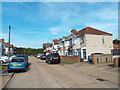
Victory Road, South Hornchurch
Victory Road is a residential cul-de-sac in the outer suburbs of east London.
Image: © Malc McDonald
Taken: 28 Aug 2017
0.02 miles
2
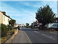
Rainham Road, South Hornchurch
Rainham Road in South Hornchurch, in the outer suburbs of east London.
Image: © Malc McDonald
Taken: 28 Aug 2017
0.07 miles
3
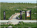
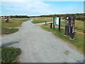
Ingrebourne Hill Bike Park
A sinuous but not very hilly course that intersects paths used by walkers and more staid cyclists at several points - as here. This is a Forestry Commission open space.
Image: © Robin Webster
Taken: 24 Apr 2011
0.10 miles
4
Rocks and Runway Lights
This is by the southern entrance to Hornchurch Country Park. The park's previous history as a WW2 airfield is recalled in the runway light artwork.
I don't know what the blue thing represents. It looks like a shower fitting, but that's probably a bad guess.
Image: © Des Blenkinsopp
Taken: 4 Jun 2013
0.10 miles
5
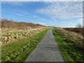
Ingrebourne Valley, near Rainham
Ingrebourne Valley is part of Hornchurch Country Park. The path ahead forms part of the National Cycle Network route 136, and is also part of the London LOOP.
Image: © Malc McDonald
Taken: 28 Aug 2017
0.12 miles
6
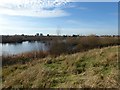
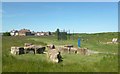
Lake Stillwell seen from the slope of Ingrebourne Hill
Ingrebourne Hill was completed in partnership between the Forestry Commission and Ingrebourne Valley Limited (IVL).The site was a former sand and gravel quarry, which was filled with a range of materials, including bricks, concrete and metal before IVL purchased the site.
The partnership between IVL and the Forestry Commission enabled a restoration scheme to be developed so that the disused site could be transformed into a country park with a high point at Ingrebourne Hill providing superb views.
Squadron Leader Ronnie Stillwell was one of 'The Few' during the Battle of Britain. In the summer of 1940 he was a young Sergeant flying Spitfires with 65 Squadron which was then based at RAF Hornchurch, now Hornchurch Country Park. Ronnie Stillwell won the Distinguished Flying Medal (DFM) for assisting downed colleagues and the Distinguished Flying Cross (DFC) for destroying three German aircraft. The lake is therefore named after him. See http://www.bbm.org.uk/airmen/Stillwell.htm
Image: © Marathon
Taken: 14 Dec 2016
0.14 miles
8
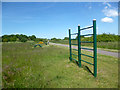
Fitness Stuff by the LOOP
This is a newly opened section of the London Loop path through the country park. The on-road section marked on the map has now been bypassed by this very pleasant route.
Lots of fitness equipment has been provided as well. Walking isn't enough any more. Jump, climb, stretch, swing, sit-up...um...sit down.
Image: © Des Blenkinsopp
Taken: 4 Jun 2013
0.14 miles
9
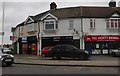
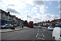
Shops on Rainham Road, South Hornchurch
Image: © David Howard
Taken: 22 Feb 2020
0.15 miles
10
The path up Ingrebourne Hill
Ingrebourne Hill was completed in partnership between the Forestry Commission and Ingrebourne Valley Limited (IVL).The site was a former sand and gravel quarry, which was filled with a range of materials, including bricks, concrete and metal before IVL purchased the site.
The partnership between IVL and the Forestry Commission enabled a restoration scheme to be developed so that the disused site could be transformed into a country park with a high point at Ingrebourne Hill providing superb views.
Image: © Marathon
Taken: 14 Dec 2016
0.15 miles