IMAGES TAKEN NEAR TO
South Street, ROMFORD, RM1 2AJ
Introduction
This page details the photographs taken nearby to South Street, RM1 2AJ by members of the Geograph project.
The Geograph project started in 2005 with the aim of publishing, organising and preserving representative images for every square kilometre of Great Britain, Ireland and the Isle of Man.

There are currently over 7.5m images from over14,400 individuals and you can help contribute to the project by visiting https://www.geograph.org.uk
Image Map (Loading...)


Getting Data...Please wait
Leaflet Map data © OpenStreetMap
Images are licensed for reuse under creativecommons.org/licenses/by-sa/2.0
Notes
- Clicking on the map will re-center to the selected point.
- The higher the marker number, the further away the image location is from the centre of the postcode.
Image Listing (27 Images Found)
Images are licensed for reuse under creativecommons.org/licenses/by-sa/2.0
Image
Details
Distance
1
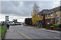
South Street, Romford
Looking south from the corner of Dymoke Road.
Image: © Trevor Harris
Taken: 22 Oct 2020
0.04 miles
3
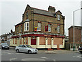
The Old Oak - another closed pub
It does not seem to be a permanent closure - yet. The "To Let" sign says it is to be let as a pub business.
Image: © Robin Webster
Taken: 2 Apr 2011
0.09 miles
5
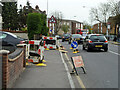
Pavement up, South Street, Romford
Something to do with gas.
Image: © Robin Webster
Taken: 2 Apr 2011
0.12 miles
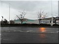
6
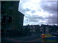
Junction of South Street and Rom Valley Way
This is the junction of South Street and Rom Valley Way, just east of Romford Town Centre, taken looking east-southeast from Rom Valley Way. The road in shot here is South Street, heading towards Romford station. Apologies for the darkness of the image - I can brighten it if needed. As you can see, the sky above isn't too friendly, so visibility wasn't the best.
Image: © Robert Lamb
Taken: 28 Aug 2009
0.16 miles
7
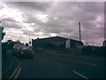
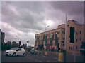
Romford Ice Rink
This is the Romford Ice Rink, as shown in John Winfield's Image, but taken head on from Rom Valley Way. Again, apologies for the darkness of the image - visibility certainly isn't at its best today! View taken looking south-southwest.
Image: © Robert Lamb
Taken: 28 Aug 2009
0.16 miles
8
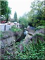
River Rom, between South St and Davidson Way, Romford
The Rom is a tributary of the Thames, and its name changes to the River Beam as it gets closer to London.
Image: © Richard Winch
Taken: 10 Apr 2017
0.18 miles
9
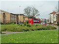
Buses on South Street, Romford, 2011
The green area at Roneo Corner has since been built on.
Image: © Robin Webster
Taken: 2 Apr 2011
0.18 miles
10
Junction of South Street and Rom Valley Way #2
This is the view looking in the opposite direction to Image The visibility is much better in this image - perhaps it was because the sun was shining on the camera in that image and the sky isn't quite so dark here. The restaurant Giorgios is just out of shot to the left. I am unsure what the building is/was at the right of the image - the red board just below it signifies it is up for sale. View taken looking west-southwest from the junction of South Street and Rom Valley Way.
Image: © Robert Lamb
Taken: 28 Aug 2009
0.19 miles