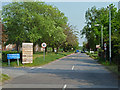
IMAGES TAKEN NEAR TO
Gladiator Way, HORNCHURCH, RM12 6EW
Introduction
This page details the photographs taken nearby to Gladiator Way, RM12 6EW by members of the Geograph project.
The Geograph project started in 2005 with the aim of publishing, organising and preserving representative images for every square kilometre of Great Britain, Ireland and the Isle of Man.

There are currently over 7.5m images from over14,400 individuals and you can help contribute to the project by visiting https://www.geograph.org.uk
Image Map
Images are licensed for reuse under creativecommons.org/licenses/by-sa/2.0
Notes
- Clicking on the map will re-center to the selected point.
- The higher the marker number, the further away the image location is from the centre of the postcode.
Image Listing (39 Images Found)
Images are licensed for reuse under creativecommons.org/licenses/by-sa/2.0
Image
Details
Distance
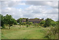
2
NHS.... Nice Hay Supplies?
The neglected lawns at the closed St. George's Hospital site have quickly reverted to lush meadows.
Image: © Des Blenkinsopp
Taken: 4 Jun 2013
0.02 miles
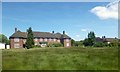
3
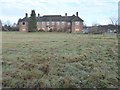
The former St George's Hospital, Hornchurch
St George's Hospital opened in 1939 as Suttons Institution and was brought into use during the Second World War to house airmen at RAF Hornchurch.
In 1948 it was renamed St George's and became part of the National Health Service. The site has been empty since 2012 and plans are in place for a new health centre on the site, with the remaining land being converted to housing. It is seen here from a footpath to the south which leads from Suttons Lane to Hornchurch Country Park.
Image: © Marathon
Taken: 14 Dec 2016
0.03 miles
4
Building, St. George's Hospital
One of many blocks on this large site. The hospital is closed and awaits a redevelopment scheme that will satisfy the planning authority.
Image: © Robin Webster
Taken: 24 Apr 2011
0.04 miles
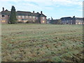
5
Internal road, St George's Hospital
A large campus, with an air of only being partly used. Either that, or severe economies have been made on property maintenance and grounds upkeep.
Image: © Robin Webster
Taken: 24 Apr 2011
0.05 miles
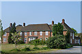
6
The former St George's Hospital, Hornchurch
St George's Hospital opened in 1939 as Suttons Institution and was brought into use during the Second World War to house airmen at RAF Hornchurch.
In 1948 it was renamed St George's and became part of the National Health Service. The site has been empty since 2012 and plans are in place for a new health centre on the site, with the remaining land being converted to housing. It is seen here from a footpath to the south which leads from Suttons Lane to Hornchurch Country Park.
Image: © Marathon
Taken: 14 Dec 2016
0.05 miles
7
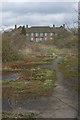
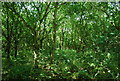
Hornchurch Country Park Extension
This picture show the recent extension to Hornchurch Country Park http://www.havering.gov.uk/index.aspx?articleid=5023. The fences have been ripped down and you can see some future archaeology in the making underfoot. In the background is St Georges Hospital http://www.nhs.uk/ServiceDirectories/pages/Hospital.aspx?id=RATGG
Image: © Glyn Baker
Taken: 2 Apr 2010
0.06 miles
10
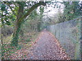
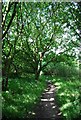
Footpath on the edge of Hornchurch Country Park
Hornchurch Country Park is the former site of Sutton's Farm airfield which opened on 3rd October 1915, from which biplanes of the Royal Flying Corps defended London in the First World War. Lieutenant William Leefe-Robinson took off from the airfield on the night of 2nd September 1916 and shot down the first German Zeppelin airship to crash over British soil. For this action he received the Victoria Cross. The airfield closed after the First World War, but the land was requisitioned in 1923 because of the expansion of the RAF and the airfield opened as a much larger fighter station, RAF Hornchurch. Fighter squadrons from Hornchurch were prominent in the Battle of France over Dunkirk and the Battle of Britain and it became one of the most famous Spitfire stations in Fighter Command. The airfield was ideally located in bomb alley to cover both London and the Thames corridor from German air attacks.
After the War it became the RAF's Aircrew Selection Centre during the 1950s. In 1962 the airfield closed and the site was sold for gravel extraction. In 1980, following ground restoration, including in-filling with landfill, the Greater London Council carried out a massive landscaping project to create Hornchurch Country Park. The road names of the local airfield housing estate commemorate the airfield and its pilots. Some of the artefacts from the old fighter station are still to be seen around the perimeter.
A new visitor centre was opened on 3rd October 2015, the 100th anniversary of the original airfield. It includes exhibition space and a cafe and has been named Ingrebourne Valley Visitor Centre as it provides a focal point and gateway to the wider landscape of the Ingrebourne Valley. It is a joint venture between Essex Wildlife Trust and the London Borough of Havering.See http://data.wildlifetrusts.org/sites/default/files/Hornchurch%20Country%20Park%20Info%20&%20Map.pdf for more information about Hornchurch Country Park.
This footpath leads to Suttons Lane. On the right beyond the wire fence is the former St George's Hospital which during the Second World War housed airmen at RAF Hornchurch - see http://www.geograph.org.uk/photo/5226960
Image: © Marathon
Taken: 14 Dec 2016
0.10 miles