IMAGES TAKEN NEAR TO
Ridgewell Grove, HORNCHURCH, RM12 5AG
Introduction
This page details the photographs taken nearby to Ridgewell Grove, RM12 5AG by members of the Geograph project.
The Geograph project started in 2005 with the aim of publishing, organising and preserving representative images for every square kilometre of Great Britain, Ireland and the Isle of Man.

There are currently over 7.5m images from over14,400 individuals and you can help contribute to the project by visiting https://www.geograph.org.uk
Image Map
Images are licensed for reuse under creativecommons.org/licenses/by-sa/2.0
Notes
- Clicking on the map will re-center to the selected point.
- The higher the marker number, the further away the image location is from the centre of the postcode.
Image Listing (8 Images Found)
Images are licensed for reuse under creativecommons.org/licenses/by-sa/2.0
Image
Details
Distance
1
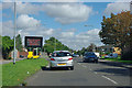
South End Road
Towards Hornchurch, where the sign tells us that essential water main works are happening on the High Street.
Image: © Robin Webster
Taken: 18 Sep 2011
0.17 miles
2
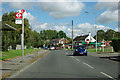
Heron Flight Avenue bus stop
A stop for route 252.
Image: © Robin Webster
Taken: 18 Sep 2011
0.18 miles
4
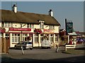
The Road to Hell?
A pub on South End Road serving the residents of the "Airfield Estate". The road to hell was paved with the good intent of Flying Officer Raimund Sanders-Draper an American airman posted to RAF Hornchurch. His exploits were the subject of a Musical Play produced at the Queens Theatre in Hornchurch in 2003. Sanders-Draper was killed in 1943 during a crash landing, he stayed with his stricken aircraft so he could avoid crashing into the local school, he had sufficient height to bail out but chose to save the children. The school in Suttons Lane was renamed Sanders-Draper in his honour.
Image: © Glyn Baker
Taken: 16 Aug 2005
0.22 miles
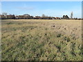
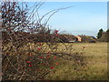
6

Ingrebourne Valley Nature Reserve
This part of the reserve http://www.wildessex.net/groupSites/Ingrebourne%20Valley.htm , close to Albyns Farm, touches into TQ5284.
Image: © Roger Jones
Taken: 31 Aug 2013
0.24 miles
7
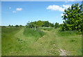
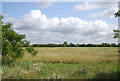
The western edge of Hornchurch Country Park
Hornchurch Country Park is the former site of Sutton's Farm airfield which opened on 3rd October 1915, from which biplanes of the Royal Flying Corps defended London in the First World War. Lieutenant William Leefe-Robinson took off from the airfield on the night of 2nd September 1916 and shot down the first German Zeppelin airship to crash over British soil. For this action he received the Victoria Cross. The airfield closed after the First World War, but the land was requisitioned in 1923 because of the expansion of the RAF and the airfield opened as a much larger fighter station, RAF Hornchurch. Fighter squadrons from Hornchurch were prominent in the Battle of France over Dunkirk and the Battle of Britain and it became one of the most famous Spitfire stations in Fighter Command. The airfield was ideally located in bomb alley to cover both London and the Thames corridor from German air attacks.
After the War it became the RAF's Aircrew Selection Centre during the 1950s. In 1962 the airfield closed and the site was sold for gravel extraction. In 1980, following ground restoration, including in-filling with landfill, the Greater London Council carried out a massive landscaping project to create Hornchurch Country Park. The road names of the local airfield housing estate commemorate the airfield and its pilots. Some of the artefacts from the old fighter station are still to be seen like this pillbox which guarded the perimeter.
A new visitor centre was opened on 3rd October 2015, the 100th anniversary of the original airfield. It includes exhibition space and a cafe and has been named Ingrebourne Valley Visitor Centre as it provides a focal point and gateway to the wider landscape of the Ingrebourne Valley. It is a joint venture between Essex Wildlife Trust and the London Borough of Havering. See http://data.wildlifetrusts.org/sites/default/files/Hornchurch%20Country%20Park%20Info%20&%20Map.pdf for more information about Hornchurch Country Park.
This is the western end of the Country Park. The houses are in Hayes Drive.
Image: © Marathon
Taken: 14 Dec 2016
0.25 miles
8
The western edge of Hornchurch Country Park
Hornchurch Country Park is the former site of Sutton's Farm airfield which opened on 3rd October 1915, from which biplanes of the Royal Flying Corps defended London in the First World War. Lieutenant William Leefe-Robinson took off from the airfield on the night of 2nd September 1916 and shot down the first German Zeppelin airship to crash over British soil. For this action he received the Victoria Cross. The airfield closed after the First World War, but the land was requisitioned in 1923 because of the expansion of the RAF and the airfield opened as a much larger fighter station, RAF Hornchurch. Fighter squadrons from Hornchurch were prominent in the Battle of France over Dunkirk and the Battle of Britain and it became one of the most famous Spitfire stations in Fighter Command. The airfield was ideally located in bomb alley to cover both London and the Thames corridor from German air attacks.
After the War it became the RAF's Aircrew Selection Centre during the 1950s. In 1962 the airfield closed and the site was sold for gravel extraction. In 1980, following ground restoration, including in-filling with landfill, the Greater London Council carried out a massive landscaping project to create Hornchurch Country Park. The road names of the local airfield housing estate commemorate the airfield and its pilots. Some of the artefacts from the old fighter station are still to be seen like this pillbox which guarded the perimeter.
A new visitor centre was opened on 3rd October 2015, the 100th anniversary of the original airfield. It includes exhibition space and a cafe and has been named Ingrebourne Valley Visitor Centre as it provides a focal point and gateway to the wider landscape of the Ingrebourne Valley. It is a joint venture between Essex Wildlife Trust and the London Borough of Havering. See http://data.wildlifetrusts.org/sites/default/files/Hornchurch%20Country%20Park%20Info%20&%20Map.pdf for more information about Hornchurch Country Park.
This is the western end of the Country Park. The houses are in Hayes Drive.
Image: © Marathon
Taken: 14 Dec 2016
0.25 miles