IMAGES TAKEN NEAR TO
Cromer Road, HORNCHURCH, RM11 1EZ
Introduction
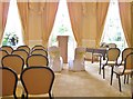
This page details the photographs taken nearby to Cromer Road, RM11 1EZ by members of the Geograph project.
The Geograph project started in 2005 with the aim of publishing, organising and preserving representative images for every square kilometre of Great Britain, Ireland and the Isle of Man.

There are currently over 7.5m images from over14,400 individuals and you can help contribute to the project by visiting https://www.geograph.org.uk
Image Map
Images are licensed for reuse under creativecommons.org/licenses/by-sa/2.0
Notes
- Clicking on the map will re-center to the selected point.
- The higher the marker number, the further away the image location is from the centre of the postcode.
Image Listing (36 Images Found)
Images are licensed for reuse under creativecommons.org/licenses/by-sa/2.0
Image
Details
Distance
1
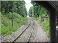
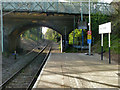
Looking towards Romford from Emerson Park station
The Romford to Upminster Line was constructed in 1893 as a branch of the London, Tilbury & Southend Railway from Upminster. This opened on 7th June 1893 at a second station in Romford which was combined with the main station at Romford in 1934. Emerson Park station was opened on 1st October 1909 as Emerson Park Halt. A video about the line can be seen at https://www.youtube.com/watch?v=_TwuKTthbTU
There is a half hourly London Overground train to either Romford and Upminster from the single bi-directional platform. This view looks under Butts Green Road towards Romford.
Image: © Marathon
Taken: 7 Jun 2017
0.12 miles
2
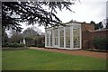
Langtons Orangey
This is the eighteenth century orangey in Image see
http://www.friendsoflangtonsgardens.co.uk/ and http://en.wikipedia.org/wiki/Langtons for more information
Image: © Glyn Baker
Taken: 20 Mar 2010
0.15 miles
3
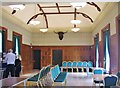
Function room at Langtons House, Hornchurch
Image: © Derek Voller
Taken: 31 May 2014
0.15 miles
4
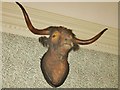
Bulls head in the function room at Langtons House
It's logical to think that this is the emblem of Hornchurch, maybe due to the history of the leather tanning industry in the village, or perhaps because of a similar head adorning St Andrew's church a few hundred yards distance. See Image for its history.
Image: © Derek Voller
Taken: 31 May 2014
0.15 miles
5
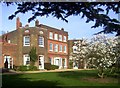
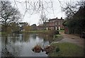
Langtons House, Hornchurch
A late 18th century former country house and garden now surrounded by suburban London.
In 1929 the last family to live there left it to the local council, Hornchurch UDC at the time, which later merged into the London Borough of Havering.
It's now a popular wedding venue, with the garden open as a very pleasant public park.
More info on Wiki. http://en.wikipedia.org/wiki/Langtons
Image: © Des Blenkinsopp
Taken: 13 Mar 2014
0.16 miles
6
View towards Romford, Emerson Park Halt, 2011
The only intermediate stopping place on the Romford - Upminster branch, now elevated to station status with no physical change apart from Overground rebranding on the signs.
Image: © Robin Webster
Taken: 9 Apr 2011
0.16 miles
7
Langtons, Hornchurch
Langtons was given to the Borough of Hornchurch in 1929, it was used as council offices until 1965 when Hornchurch became part of Havering. See
http://www.friendsoflangtonsgardens.co.uk/ and http://en.wikipedia.org/wiki/Langtons for more information
Image: © Glyn Baker
Taken: 20 Mar 2010
0.16 miles
10
The yellow marriage room, Langtons House
The Western addition to the original building is this beautifully decorated marriage room. The Eastern wing contains its twin, but in pale blue.
Image: © Derek Voller
Taken: 31 May 2014
0.16 miles