IMAGES TAKEN NEAR TO
Lower Broad Street, DAGENHAM, RM10 9JJ
Introduction
This page details the photographs taken nearby to Lower Broad Street, RM10 9JJ by members of the Geograph project.
The Geograph project started in 2005 with the aim of publishing, organising and preserving representative images for every square kilometre of Great Britain, Ireland and the Isle of Man.

There are currently over 7.5m images from over14,400 individuals and you can help contribute to the project by visiting https://www.geograph.org.uk
Image Map
Images are licensed for reuse under creativecommons.org/licenses/by-sa/2.0
Notes
- Clicking on the map will re-center to the selected point.
- The higher the marker number, the further away the image location is from the centre of the postcode.
Image Listing (27 Images Found)
Images are licensed for reuse under creativecommons.org/licenses/by-sa/2.0
Image
Details
Distance
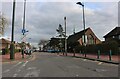
1
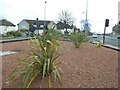
Traffic Island, Dagenham
This island is at the junction of Heathway meeting the A13 dual carriageway, (on the right).
A footpath passes through the red stone and phormium planting (alien style!).
Image: © David Anstiss
Taken: 31 Mar 2013
0.15 miles
2
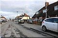
Downing Road, Dagenham
All the traffic heading east along Gorsebrook Road into Dagenham is now filtered up this little road instead. I don't think it's suitable in comparison with the old route.
Image: © David Howard
Taken: 19 Mar 2023
0.17 miles
3
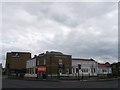
Chequers Corner, Dagenham
This Brewer's Fayre Restaurant is on the junction of the A13 (dual carriageway - between Rainham and central London) and Chequers Lane (on the right).
It was built recently in 2012, with the large Premier Inn motel behind it.
They opened in time for the London 2012 Olympics.
Image: © David Anstiss
Taken: 31 Mar 2013
0.18 miles
5
Gorsebrook Road, Dagenham
It's a long road but you can't use this end of it unless you need to park there.
Image: © David Howard
Taken: 19 Mar 2023
0.20 miles
7
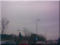
Amazing leaf-shaped street lights on A1306 Ripple Road
The A1306 (previously the A13 before the new Dagenham-Aveley section was constructed in 1998) is lit with these amazing leaf-shaped street lights called Urbis Sepales, on columns which represent flower stems, but the name of which I have forgotten. They look excellent in this tree-lined setting! View taken looking east along the A13 New Road.
Image: © Robert Lamb
Taken: 7 Mar 2009
0.20 miles
8
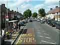
Arnold Road (U) bus stop on Heathway, Dagenham
Served by routes 173, 174, 175 and MB1 towards Becontree Heath or Rush Green.
Image: © Robin Webster
Taken: 25 Jun 2011
0.21 miles
9
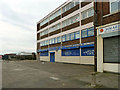
Transport House, New Road, Dagenham
The home of the local branch of the Transport and General Workers Union.
Image: © Robin Webster
Taken: 2 Apr 2011
0.21 miles
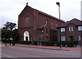
10
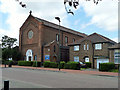
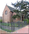
St Peter's Catholic Church, Dagenham
Complete with priest's house, on Goresbrook Road.
Image: © Robin Webster
Taken: 25 Jun 2011
0.21 miles