IMAGES TAKEN NEAR TO
First Avenue, DAGENHAM, RM10 9AT
Introduction
This page details the photographs taken nearby to First Avenue, RM10 9AT by members of the Geograph project.
The Geograph project started in 2005 with the aim of publishing, organising and preserving representative images for every square kilometre of Great Britain, Ireland and the Isle of Man.

There are currently over 7.5m images from over14,400 individuals and you can help contribute to the project by visiting https://www.geograph.org.uk
Image Map
Images are licensed for reuse under creativecommons.org/licenses/by-sa/2.0
Notes
- Clicking on the map will re-center to the selected point.
- The higher the marker number, the further away the image location is from the centre of the postcode.
Image Listing (8 Images Found)
Images are licensed for reuse under creativecommons.org/licenses/by-sa/2.0
Image
Details
Distance
2
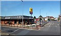
Mountain of Fire and Miracles Ministries
This impressively entitled sect originated in Nigeria and started in the UK in 1996.
Image: © Robin Webster
Taken: 2 Apr 2011
0.14 miles
3

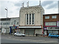
Ford's Stamping Operations
This is a picture of one of the remaining parts of Ford’s Dagenham operation. This is the stamping works. The road beside the plant is not a public right of way but is Ford's private road. The Art Deco building on the other side of the A1306 used to be the Princess Bowling Alley. It is now the “Mountain of Fire & Miracle Ministries”.
Image: © Glyn Baker
Taken: 8 Sep 2005
0.17 miles
4
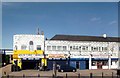
Dalin Tyres and Wheels
Just opposite the car factory is this place where they'll sort you out when the wheels fall off.
Image: © Des Blenkinsopp
Taken: 4 Jun 2013
0.18 miles
5

Development Site Formerly Ford Dagenham Plant
Taken over a robust wall by poking the lens through the razor wire.
Image: © Glyn Baker
Taken: 10 May 2020
0.18 miles
6
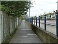
Pavement, A1306 New Road Dagenham
At a lower level than the road - was this a result of road improvements?
Image: © Robin Webster
Taken: 2 Apr 2011
0.19 miles
7
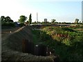
Washlands Scheme
This picture shows the construction of the Washlands Flood Storage area renewal project. This is an area designed to hold flood water from the River Beam protecting near by houses from flooding. The £2m project is designed to restore the dikes, which have sunk over the years due to underlying soft peat subsiding. New dikes are being constructed from more solid material from below the peat layer.
Image: © Glyn Baker
Taken: 7 Sep 2005
0.22 miles
8
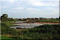
Wantz Stream Improvements
In 2005 the dikes that prevent flooding from the Beam River and Wantz Stream were reinforced in the Image, the Beam River drains an area of approximately 66sq km so there is the need to control lot of water. Today the whole area is being reshaped to improve flood defences, public amenity and wildlife value of the Image
Image: © Glyn Baker
Taken: 3 Oct 2010
0.24 miles