IMAGES TAKEN NEAR TO
Manor Road, DAGENHAM, RM10 8BB
Introduction
This page details the photographs taken nearby to Manor Road, RM10 8BB by members of the Geograph project.
The Geograph project started in 2005 with the aim of publishing, organising and preserving representative images for every square kilometre of Great Britain, Ireland and the Isle of Man.

There are currently over 7.5m images from over14,400 individuals and you can help contribute to the project by visiting https://www.geograph.org.uk
Image Map
Images are licensed for reuse under creativecommons.org/licenses/by-sa/2.0
Notes
- Clicking on the map will re-center to the selected point.
- The higher the marker number, the further away the image location is from the centre of the postcode.
Image Listing (14 Images Found)
Images are licensed for reuse under creativecommons.org/licenses/by-sa/2.0
Image
Details
Distance
1
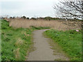
Possible terminal basin, Romford Canal
This reed bed in a large shallow depression west of the Beam River may have been the temporary terminal basin of the never completed canal. Early maps suggest a basin here, just north of the road crossing by what is now the A1112. No work was done north from this point, which would have soon involved a four lock flight.
Image: © Robin Webster
Taken: 2 Apr 2011
0.15 miles
2
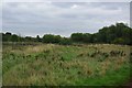
Dagenham!
Not the sort of landscape you expect in Dagenham! This is part of the Image
Image: © Glyn Baker
Taken: 3 Oct 2010
0.16 miles
3
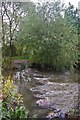
Beam River
This is the Beam River in the Image This river drains around 66sq km of the surrounding real estate. http://www.barking-dagenham.gov.uk/8-leisure-envir/park-country/beam-valley.html there is no way the rocks are part of the natural geology.
Image: © Glyn Baker
Taken: 3 Oct 2010
0.17 miles
5
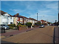
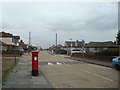
Rainham Road South, Dagenham
Rainham Road South in Dagenham, in the outer suburbs of east London.
Image: © Malc McDonald
Taken: 28 Aug 2017
0.19 miles
6
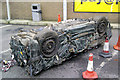
Scrappy New Year
This crushed car was at a filling station in Dagenham, on the first day of 2011. I don't know why it was dumped here.
Image: © william
Taken: 1 Jan 2011
0.21 miles
7
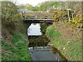
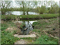
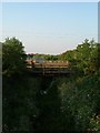
Bridges over Beam River
Between a water company depot on the left and a pumping station on the right.
Image: © Robin Webster
Taken: 2 Apr 2011
0.21 miles
9
Footbridges On The Beam River
Even in urban Dagenham given the opportunity nature claims back what it can. The picture was taken from the bridge on the A112 looking north east.
Image: © Glyn Baker
Taken: 16 Aug 2005
0.23 miles
10
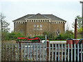
Pumping station by Beam River
A grade II listed building, 'after 1897'.
Image: © Robin Webster
Taken: 2 Apr 2011
0.23 miles