1
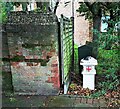
Coal duty boundary marker, south side of Wood Lane
Coal duty boundary marker.
Milestone Society National ID: EX_CTROM02bm
Image: © Paul Jones
Taken: 12 Oct 2020
0.02 miles
2
A124 - welcome to Barking & Dagenham
At the boundary with Havering, Rush Green Road becomes Wood Lane.
Image: © Robin Webster
Taken: 18 Sep 2011
0.05 miles
3
A124 Rush Green Road
Heading west with Barton Avenue bus stops left and right.
Image: © Robin Webster
Taken: 18 Sep 2011
0.07 miles
4
The very strange golf driving range at Wantz Lake
Wantz Lake is a circular artificial lake on the upper reaches of the Wantz Stream. It serves as a balancing reservoir to control flooding further downstream.
It also features in a golf driving range although I would imagine the majority of balls must end up in the lake. A high net on the far side is to stop the golf balls ending up hitting the houses beyond although one would imagine many balls hitting the netting would also end up in the lake! See also http://www.geograph.org.uk/photo/5227019
Image: © Marathon
Taken: 14 Dec 2016
0.14 miles
5
Wantz Lake
Wantz Lake is a circular artificial lake on the upper reaches of the Wantz Stream. It serves as a balancing reservoir to control flooding further downstream.
It also features in a golf driving range although I would imagine the majority of balls must end up in the lake. The high net is to stop the golf balls ending up hitting the houses beyond although one would imagine many balls hitting the netting would also end up in the lake! See also http://www.geograph.org.uk/photo/5227021
Image: © Marathon
Taken: 14 Dec 2016
0.17 miles
6
Path from Wood Lane to Fambridge Road or Crow Lane
Image: © Robin Webster
Taken: 25 Jun 2011
0.20 miles
7
Civic Centre, Rainham Road North (1)
Built in 1936-37 by E. Berry Webber with F.C. Lloyd, the Borough Engineer. A striking building which borrows from classical architecture - the portico, its symmetry and use of brick - but which is most definitely also "go-ahead and modern" (Pevsner). Grade II listed.
It serves as the main building of the London Borough of Barking and Dagenham.
Image: © Stephen Richards
Taken: Unknown
0.21 miles
8
Civic Centre, Rainham Road North (2)
Built in 1936-37 by E. Berry Webber with F.C. Lloyd, the Borough Engineer. A striking building which borrows from classical architecture - the portico, its symmetry and use of brick - but which is most definitely also "go-ahead and modern" (Pevsner). You can't see from the picture, but the panels in the frieze represent Engineering, Local Government and Navigation. Grade II listed.
It serves as the main building of the London Borough of Barking and Dagenham, whose proud boast can be seen above the portico. A wider view can be found here
Image
Image: © Stephen Richards
Taken: Unknown
0.21 miles
9
A124 Rush Green Road
Heading west with Clayton Road bus stop on the left.
Image: © Robin Webster
Taken: 18 Sep 2011
0.22 miles
10
Pitch and putt golf course, Central Park
Central Park is situated between Rainham Road North and Rush Green Road, and was laid out behind Dagenham Civic Centre which is a superb example of late-1930s civic architecture. It was built in 1937, as was the fire station beyond it. The grand scale of Central Park reflects the dramatic increase in size of Dagenham between the Wars. The pitch and putt golf course is along the northern boundary of the park.
Image: © Marathon
Taken: 14 Dec 2016
0.23 miles


