IMAGES TAKEN NEAR TO
Station Approach, OXTED, RH8 9EW
Introduction
This page details the photographs taken nearby to Station Approach, RH8 9EW by members of the Geograph project.
The Geograph project started in 2005 with the aim of publishing, organising and preserving representative images for every square kilometre of Great Britain, Ireland and the Isle of Man.

There are currently over 7.5m images from over14,400 individuals and you can help contribute to the project by visiting https://www.geograph.org.uk
Image Map
Images are licensed for reuse under creativecommons.org/licenses/by-sa/2.0
Notes
- Clicking on the map will re-center to the selected point.
- The higher the marker number, the further away the image location is from the centre of the postcode.
Image Listing (145 Images Found)
Images are licensed for reuse under creativecommons.org/licenses/by-sa/2.0
Image
Details
Distance
1
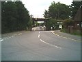
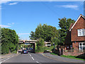
Railway Bridge, Bluehouse Lane
Bluehouse Lane Oxted, with a dip in the road under the railway bridge to increase the clearance for vehicles under the bridge; Oxted Station Approach is to the right - before the bridge.
Image: © Brian Green
Taken: 13 Jun 2007
0.01 miles
2
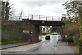
Railway bridge over Bluehouse Lane, Oxted
Image: © Ed of the South
Taken: 1 Sep 2013
0.01 miles
4
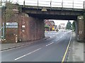
Railway bridge at northern end of Oxted station
The church is visible through the arch. Remains of recent snowfall can be seen on the far pavements and church roof.
Image: © David Martin
Taken: 25 Jan 2013
0.03 miles
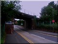
5
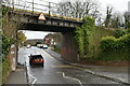
Bluehouse Lane railway bridge
The bridge carries the railway over Bluehouse Lane. The approach road to Oxted station is on the right.
Image: © Stephen Craven
Taken: 13 Sep 2012
0.03 miles
8
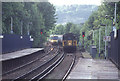
Oxted Station
Oxted has long been an important Surrey junction although perhaps less so than it once was with both routes to the south truncated. The line is electrified, but there was in 2004, and still is now, plenty of diesel activity on the Uckfield services. This is the north end of the station with a backdrop of the North Downs.
Image: © Stephen McKay
Taken: Unknown
0.04 miles
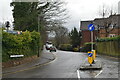
9
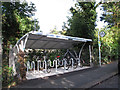
Oxted station cycle parking
A recent and high quality cycle parking facility on the station approach road.
Image: © Stephen Craven
Taken: 13 Sep 2012
0.04 miles
10
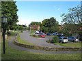
Site of the former St Mary's hall
St Mary's church hall used to be on this site. It was demolished when the new community hall Image replaced it, and the site is now a car park.
Image: © Stephen Craven
Taken: 13 Sep 2012
0.05 miles