IMAGES TAKEN NEAR TO
Moorhouse Road, OXTED, RH8 0SR
Introduction
This page details the photographs taken nearby to Moorhouse Road, RH8 0SR by members of the Geograph project.
The Geograph project started in 2005 with the aim of publishing, organising and preserving representative images for every square kilometre of Great Britain, Ireland and the Isle of Man.

There are currently over 7.5m images from over14,400 individuals and you can help contribute to the project by visiting https://www.geograph.org.uk
Image Map
Images are licensed for reuse under creativecommons.org/licenses/by-sa/2.0
Notes
- Clicking on the map will re-center to the selected point.
- The higher the marker number, the further away the image location is from the centre of the postcode.
Image Listing (12 Images Found)
Images are licensed for reuse under creativecommons.org/licenses/by-sa/2.0
Image
Details
Distance
3
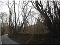
Ridlands Lane, Crockham Hill, Kent
The road connects Westerham Road (A25) and Kent Hatch Road (B269), through The High Chart woodland.
Image: © Oast House Archive
Taken: 29 Dec 2008
0.08 miles
4
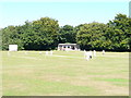
Cricket Pitch near Limpsfield Chart
The quintessential English summer Sunday scene.
Image: © Richard Mascall
Taken: 29 Aug 2005
0.12 miles
5
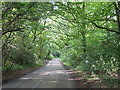
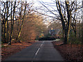
Moorhouse Road, Limpsfield Chart
Limpsfield Chart is part of High Chart, a largely wooded National Trust site on the Greensand Ridge. Moorhouse Road cuts through the centre of the woods.
Image: © Marathon
Taken: 1 Jul 2017
0.14 miles
7
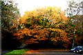
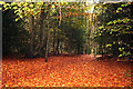
The Chart:: Autumn woodland
Several areas of the North Downs are referred to as 'The Chart': The grid reference will make clear which one of these is the subject of this photograph.
Image: © Dr Neil Clifton
Taken: 5 Nov 2010
0.18 miles
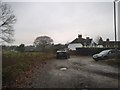
10
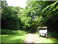
Entrance to High Chart
This is an entry to High Chart, a largely wooded National Trust site on the Greensand Ridge. It is seen from a car park off Moorhouse Road.
Image: © Marathon
Taken: 1 Jul 2017
0.20 miles