IMAGES TAKEN NEAR TO
Knowles Road, HORLEY, RH6 8PQ
Introduction
This page details the photographs taken nearby to Knowles Road, RH6 8PQ by members of the Geograph project.
The Geograph project started in 2005 with the aim of publishing, organising and preserving representative images for every square kilometre of Great Britain, Ireland and the Isle of Man.

There are currently over 7.5m images from over14,400 individuals and you can help contribute to the project by visiting https://www.geograph.org.uk
Image Map
Images are licensed for reuse under creativecommons.org/licenses/by-sa/2.0
Notes
- Clicking on the map will re-center to the selected point.
- The higher the marker number, the further away the image location is from the centre of the postcode.
Image Listing (18 Images Found)
Images are licensed for reuse under creativecommons.org/licenses/by-sa/2.0
Image
Details
Distance
1
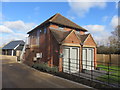
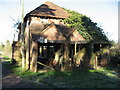
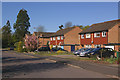
Farm Building Conversion, Horley
This was the Grainary at Landens Farm. It has been converted into a three bedroomed house as part of the new Malthouse Lane development on the north western side of Horley. This image Image shows the building in February 2008, before renovation.
Image: © Richard Rogerson
Taken: 10 Mar 2019
0.10 miles
2
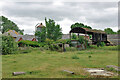
Landens Farm, Meath Green, 2010
Now mostly demolished with the stable block converted to housing, and surrounded by housing.
Image: © Robin Webster
Taken: 18 Jul 2010
0.10 miles
3
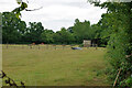
Fields with cattle, Meath Green, 2010
Image: © Robin Webster
Taken: 18 Jul 2010
0.11 miles
4
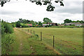
Field by footpath 411 Horley, 2010
The field is now part of a housing estate. Across the field is Landens Farm.
Image: © Robin Webster
Taken: 18 Jul 2010
0.13 miles
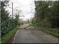
7
Poynes Road at the junction of Meath Green Lane
Image: © David Howard
Taken: 31 Jan 2016
0.17 miles
8
Meath Green Lane, Horley
The road hase been closed since September 2018 (due to open May 2019) while Sutton and East Surrey (SES) Water has been increasing the size of the existing water pipe. The project involves laying approximately 2,570m of a new 250mm main. The road has been closed except for access but last Sunday there was no access due to high winds bringing down a tree.
Image: © Richard Rogerson
Taken: 10 Mar 2019
0.18 miles
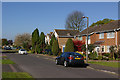
10
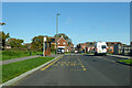
Webber Street, Westvale Park, Horley
The bus stop, served by routes 422 and 424, is called Tanner Crescent, which is a right turn ahead, closer to the stop for the other direction.
Image: © Robin Webster
Taken: 18 Nov 2022
0.19 miles