IMAGES TAKEN NEAR TO
Dorking Road, DORKING, RH5 6SB
Introduction
This page details the photographs taken nearby to Dorking Road, RH5 6SB by members of the Geograph project.
The Geograph project started in 2005 with the aim of publishing, organising and preserving representative images for every square kilometre of Great Britain, Ireland and the Isle of Man.

There are currently over 7.5m images from over14,400 individuals and you can help contribute to the project by visiting https://www.geograph.org.uk
Image Map
Images are licensed for reuse under creativecommons.org/licenses/by-sa/2.0
Notes
- Clicking on the map will re-center to the selected point.
- The higher the marker number, the further away the image location is from the centre of the postcode.
Image Listing (70 Images Found)
Images are licensed for reuse under creativecommons.org/licenses/by-sa/2.0
Image
Details
Distance
1
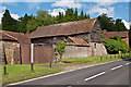
Hunters Moon Farm
Outbuildings of Hunters Moon Farm, alongside Dorking Road.
Image: © Ian Capper
Taken: 30 Jun 2012
0.03 miles
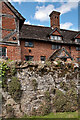
2
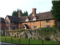
Old Hatch Farmhouse
Another of the attractive old buildings in the village. Some parts of this one date back to the 16th century.
Image: © Des Blenkinsopp
Taken: 5 Sep 2023
0.05 miles
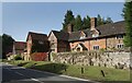
3
Old Hatch Farmhouse
Part of Old Hatch Farmhouse and the wall in front of it (see Image for wider view). Note the insertion of pieces of stone in the mortar of the wall, possibly to protect it - a feature known as "galleting".
Image: © Ian Capper
Taken: 30 Jun 2012
0.05 miles
4
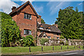
Old Hatch Farmhouse
Dating originally from the 16th century with 17th,19th and 20th century additions. Grade II* listed - see www.historicengland.org.uk/listing/the-list/list-entry/1377801. For close up of the wall in front, see Image
Image: © Ian Capper
Taken: 30 Jun 2012
0.05 miles
5
Old Houses, Abinger Hammer
Historic building on the north side of Guildford Road. It is half-timbered in parts, with brick infill. Note the ornate chimneys.
Image: © Colin Smith
Taken: 7 Oct 2007
0.06 miles
6
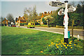
Abinger Hammer in Spring
Looking west along the A25 to the clock.
Image: © Colin Smith
Taken: Unknown
0.07 miles
7
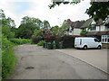
Rad Lane, Abinger Hammer
Rad Lane is a driveway leading to a few houses in the Surrey village of Abinger Hammer. The lane is a public right of way as a bridleway, and is on route 22 of the National Cycle Network.
Image: © Malc McDonald
Taken: 3 Jun 2022
0.08 miles
8
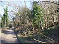
Piney Copse
Byway passing small piece of woodland east of Gomshall.
Image: © Colin Smith
Taken: 26 Jan 2008
0.11 miles
9
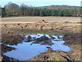
By Hunters Moon Farm
Manure and standing water on a bare field below the wooded North Downs.
Image: © Colin Smith
Taken: 26 Jan 2008
0.11 miles
10
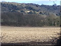
Field West of Abinger Hammer
Bare field, with spooked rooks over it. Behind is the wooded scarp slope of Hackhurst Downs.
Image: © Colin Smith
Taken: 26 Jan 2008
0.12 miles