IMAGES TAKEN NEAR TO
Sheephouse Lane, DORKING, RH5 6QH
Introduction
This page details the photographs taken nearby to Sheephouse Lane, RH5 6QH by members of the Geograph project.
The Geograph project started in 2005 with the aim of publishing, organising and preserving representative images for every square kilometre of Great Britain, Ireland and the Isle of Man.

There are currently over 7.5m images from over14,400 individuals and you can help contribute to the project by visiting https://www.geograph.org.uk
Image Map (Loading...)


Getting Data...Please wait
Leaflet Map data © OpenStreetMap
Images are licensed for reuse under creativecommons.org/licenses/by-sa/2.0
Notes
- Clicking on the map will re-center to the selected point.
- The higher the marker number, the further away the image location is from the centre of the postcode.
Image Listing (40 Images Found)
Images are licensed for reuse under creativecommons.org/licenses/by-sa/2.0
Image
Details
Distance
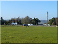
1
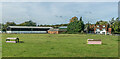
Coast Hill Farm
Farm and business park in Wotton.
Image: © Ian Capper
Taken: 11 Oct 2021
0.04 miles
2
Looking south off Sheephouse Lane near Wotton
On the left is the western edge of a collection of small commercial units collectively marketed as the 'Surrey Hills Business Park'
Image: © Jonathan Hutchins
Taken: 11 Jun 2011
0.05 miles
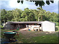
4
Outdoor school ('man?ge') at Coast Hill Farm
Image: © Jonathan Hutchins
Taken: 10 Jun 2011
0.06 miles
5
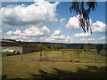
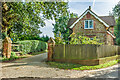
House, horse, mast
The house is called Coast Hill.
Image: © Robin Webster
Taken: 4 Mar 2011
0.07 miles
6
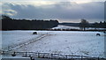
Surrey Hills south-east of Wotton
On a dark December morning. Sylvanus Wood is on the left, while the hedge running across the middle distance from right to left marks Wolvens Lane, designated a BOAT (Byway Open to All Traffic). Upon entering the wood it takes a right-angle along the wood's edge. Wolvens Lane is heavily used by 4x4s and trail bikes, some illegally.
Image: © Jonathan Hutchins
Taken: 27 Dec 2010
0.12 miles
7
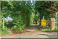
Wolvens Lane
Byway between Coldharbour and Wotton, seen here at its Wotton end. Although it is a "BOAT" (Byway open to all traffic), the sign refers to a temporary closure to four wheel drive vehicles, to avoid damage to recent repairs, and a consultation is currently under way to make the closure permanent.
Image: © Ian Capper
Taken: 11 Oct 2021
0.12 miles
8
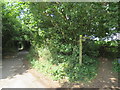
Sheephouse Lane, Wotton
Sheephouse Lane, in the Surrey village of Wotton. A public footpath runs parallel to the lane, separated from the road by a line of trees.
Image: © Malc McDonald
Taken: 28 Jul 2019
0.12 miles
9
Tillingbourne Lodge
19th Century former lodge to a large house, Tillingbourne House, which had been built by the Duke of Norfolk to replace Lonesome Lodge, a Palladian mansion further up the valley which had been built in 1740, which the Duke had purchased in 1840. Tillingbourne House was itself demolished in 1968, to be replaced by a modernist building which was then in turn demolished and replaced in the late 2010s.
Image: © Ian Capper
Taken: 11 Oct 2021
0.13 miles
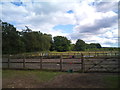
10
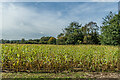
Off Sheephouse Lane
Farmland off Sheephouse Lane.
Image: © Ian Capper
Taken: 11 Oct 2021
0.13 miles