
IMAGES TAKEN NEAR TO
Radnor Lane, DORKING, RH5 6NW
Introduction
This page details the photographs taken nearby to Radnor Lane, RH5 6NW by members of the Geograph project.
The Geograph project started in 2005 with the aim of publishing, organising and preserving representative images for every square kilometre of Great Britain, Ireland and the Isle of Man.

There are currently over 7.5m images from over14,400 individuals and you can help contribute to the project by visiting https://www.geograph.org.uk
Image Map
Images are licensed for reuse under creativecommons.org/licenses/by-sa/2.0
Notes
- Clicking on the map will re-center to the selected point.
- The higher the marker number, the further away the image location is from the centre of the postcode.
Image Listing (21 Images Found)
Images are licensed for reuse under creativecommons.org/licenses/by-sa/2.0
Image
Details
Distance
1

Youth Hostel, Holmbury St Mary
Located at the end of Radnor Lane, this building dates from 1935 and is surrounded by 4,000 acres of woodland in an Area of Outstanding Natural Beauty. Its postcode is RH5 6NW.
Image: © David Hillas
Taken: 27 Sep 2008
0.07 miles
2
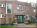
Holmbury St. Mary Youth Hostel main entrance
Originally an Art Deco purpose built youth hostel, dating from 1935 or 1937, it now has double glazed uPVC windows but retains a wealth of original features such as tiled walls in the lobby and stairwell, and a frieze or mural in the dining room / lounge. A great location too. Lovely walks abound on surrounding common and woodland areas.
Image: © Jeremy Bolwell
Taken: 23 Jul 2011
0.07 miles
3
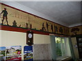
Part of the frieze inside Holmbury St. Mary Youth Hostel
Painted in 1937, when this purpose-built hostel was opened, the frieze features people associated with the build, such as the architect, builders, locals and youth hostellers of that poignant pre-war era. The building is also depicted here too.
Image: © Jeremy Bolwell
Taken: 24 Jul 2011
0.08 miles
4
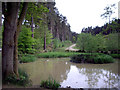
Pond on the edge of the Hurtwood
Image: © Tansy Forrest-Takano
Taken: 9 May 2009
0.10 miles
5

Radnor Lane entrance to youth hostel
Radnor Lane rises up from the Horsham Road at the bottom of the valley, to serve a handful of dwellings and Holmbury St Mary youth hostel, as well several bridleways and footpaths into the forest. These steps used to provide the shortest way in for those arriving on foot up the lane, but have been closed for many years, presumably because they are steeply raked, and a hand rail would be costly. Perhaps no-one arrives on foot?
Image: © Hugh Craddock
Taken: 3 Jan 2025
0.11 miles
6
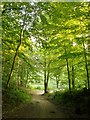
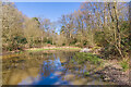
Track through the Hurtwood
A little way ahead the track swings right and runs between two ponds http://www.geograph.org.uk/photo/4540987
Woodland cover here is largely beech and ash, though there are extensive tracts of conifer plantation.
Image: © Stefan Czapski
Taken: 25 Jun 2015
0.12 miles
8
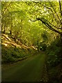
Radnor Lane
A hollow lane, one of many in the Greensand country. This one leads uphill to the Holmbury youth hostel (and a useful public car-park not marked on OS maps).
Image: © Stefan Czapski
Taken: 25 Jun 2015
0.13 miles
9
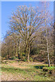
Pond
A partly dried up pond in Hurt Wood.
Image: © Ian Capper
Taken: 4 Apr 2023
0.13 miles
10
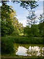
Pond in the Hurtwood
View south across the pond, towards a track which runs up a wooded valley towards the summit of Holmbury Hill. The OS plots the pond on the 1:25K mapping, but - curiously - not on the larger scale mappings. I took the photo while standing on a raised causeway, with my back to a second pond at lower level. The second pond is less overgrown with reeds - but seems to have escaped the notice of the OS altogether.
My guess is that these ponds owe their origin to the iron industry which flourished in these hills in the centuries before the Industrial Revolution. If I'm right, then there may well be more ponds (or traces of ponds) along the valley.
Image: © Stefan Czapski
Taken: 25 Jun 2015
0.14 miles