IMAGES TAKEN NEAR TO
Mickleham Downs, DORKING, RH5 6EG
Introduction
This page details the photographs taken nearby to Mickleham Downs, RH5 6EG by members of the Geograph project.
The Geograph project started in 2005 with the aim of publishing, organising and preserving representative images for every square kilometre of Great Britain, Ireland and the Isle of Man.

There are currently over 7.5m images from over14,400 individuals and you can help contribute to the project by visiting https://www.geograph.org.uk
Image Map
Images are licensed for reuse under creativecommons.org/licenses/by-sa/2.0
Notes
- Clicking on the map will re-center to the selected point.
- The higher the marker number, the further away the image location is from the centre of the postcode.
Image Listing (161 Images Found)
Images are licensed for reuse under creativecommons.org/licenses/by-sa/2.0
Image
Details
Distance
1
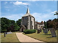
St Michael's Church, Mickleham
An earlier church on this site was mentioned in the Domesday Book.
See http://www.leatherheadweb.org.uk/mickleham/history_m.html for further information.
Image: © Roger Miller
Taken: 16 Jul 2005
0.06 miles
2
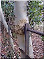
Beech tree with an iron railing through it, Mickleham
Along the lane which runs uphill from the south side of Mickleham churchyard, beech trees have grown - or been planted - close to this iron fence. In places the young trees have bent the railings of the fence, but in quite a few instances the tree, in growing, has enveloped a railing. In the case shown here, the young beech tree now has a substantial iron bar passing straight through it.
Image: © Stefan Czapski
Taken: 20 Feb 2012
0.11 miles
3
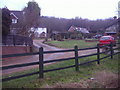
School Lane Mickleham
Box Hill is in the background
Image: © David Howard
Taken: 8 Feb 2010
0.13 miles
4
Mickleham Bends A24 Autumn 2006
This is looking across the dual carriageway of the A24 showing one of the appealing houses in Mickleham village.
Image: © Denis Loretto
Taken: Unknown
0.13 miles
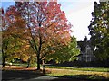
5
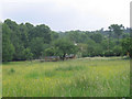
Meadow in Mickleham
This small meadow (about 1 hectare) is enclosed by public footpaths on all four sides.
Image: © Stephen Craven
Taken: 11 Jun 2007
0.14 miles
7
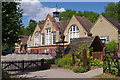
St Michael's School, Mickleham
A Church of England First School on this site since 1907.
Image: © Ian Capper
Taken: 5 Jul 2010
0.15 miles
8

Snail-shell in the woods, Mickleham Downs
Found in leaf-litter, under beech trees. I didn't measure it, but I'd say this specimen was at least 45mm long. I think the only snails I've ever seen of this size were Roman ones, on the Berkshire Downs.
Image: © Stefan Czapski
Taken: 17 Mar 2016
0.16 miles
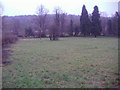
9

Farmland on the downland slopes above Mickleham
These are the chalk slopes to the east of the River Mole. The hills in the distance are the North Downs to the east of the Mole Gap (with perhaps a glimpse of the Greensand ridge near Leith Hill).
An adjacent field was being grazed by sheep, but I notice that the OS identifies the area as part of the Mickleham Stud Farm estate.
Image: © Stefan Czapski
Taken: 17 Mar 2016
0.16 miles
10
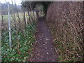
Footpath between Dell Close and School Lane, Mickleham
You can just see the North Downs on the left
Image: © David Howard
Taken: 8 Feb 2010
0.17 miles