IMAGES TAKEN NEAR TO
Chapel Lane, DORKING, RH5 6AH
Introduction
This page details the photographs taken nearby to Chapel Lane, RH5 6AH by members of the Geograph project.
The Geograph project started in 2005 with the aim of publishing, organising and preserving representative images for every square kilometre of Great Britain, Ireland and the Isle of Man.

There are currently over 7.5m images from over14,400 individuals and you can help contribute to the project by visiting https://www.geograph.org.uk
Image Map
Images are licensed for reuse under creativecommons.org/licenses/by-sa/2.0
Notes
- Clicking on the map will re-center to the selected point.
- The higher the marker number, the further away the image location is from the centre of the postcode.
Image Listing (74 Images Found)
Images are licensed for reuse under creativecommons.org/licenses/by-sa/2.0
Image
Details
Distance
3
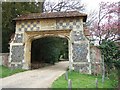
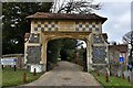
Arch Leading to 'Camilla'
The blue plaque reads: "In this village, Fanny Burnley, novelist and diarist and her husband Gen. D'Arblay built their cottage 'Camilla'. They lived in Westhumble 1797-1801."
Image: © Martyn Davies
Taken: 26 Apr 2006
0.03 miles
4
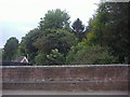
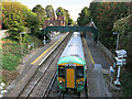
Boxhill & Westhumble station, 1990
View northward, towards London: ex-LBSCR London - Sutton - Dorking North - Horsham - South Coast/Portsmouth line. This was just after the Great Storm of 25 January 1990 and on the left can be seen the remains of a tree that fell on the Up side.
Image: © Ben Brooksbank
Taken: 11 Mar 1990
0.04 miles
5
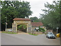
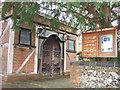
Gateway in Westhumble, near Dorking
A gateway in the village of Westhumble, in Surrey.
Image: © Malc McDonald
Taken: 28 Jul 2019
0.04 miles
6
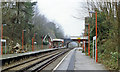
Box Hill & Westhumble Station
The Leatherhead-Dorking line passes through the village of Westhumble; Box Hill is further to the south-east. The line was built by the London, Brighton & South Coast Railway, and the station opened in 1867. According to Dendy Marshall's 'History of the Southern Railway' it has at one time or another been known as 'West Humble', 'Boxhill & Burford Bridge' (for much of its history) and 'Box Hill'.
This is the view in the 'up' direction - towards Leatherhead and London. At the northern end of the station is a footbridge, and beyond that a brick-built road bridge. For a view taken from the road bridge in 1961, see Ben Brooksbank's Image
Image: © Stefan Czapski
Taken: 7 Feb 2012
0.05 miles
7
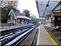
Train at West Humble
I'm up on the road bridge in the same place as Ben Brooksbank must have been 53 years ago when he took this one. Image
Surprisingly few changes. For the convenience of passengers the footbridge has lost its roof, so you get wet in the rain, and smaller, harder to read from the train nameboards have replaced the big old ones.
Cameras and lights of course, but the main difference, and it's one I have often noticed when comparing with old pictures, is how leafier things are today.
Roads, railways and canals all seemed to have less foliage around back then.
Image: © Des Blenkinsopp
Taken: 18 Sep 2014
0.05 miles
8
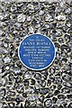
Westhumble: Fanny Burney blue plaque on the Leladene entrance
Image: © Michael Garlick
Taken: 31 Mar 2019
0.05 miles