IMAGES TAKEN NEAR TO
Coles Lane, DORKING, RH5 5LT
Introduction
This page details the photographs taken nearby to Coles Lane, RH5 5LT by members of the Geograph project.
The Geograph project started in 2005 with the aim of publishing, organising and preserving representative images for every square kilometre of Great Britain, Ireland and the Isle of Man.

There are currently over 7.5m images from over14,400 individuals and you can help contribute to the project by visiting https://www.geograph.org.uk
Image Map
Images are licensed for reuse under creativecommons.org/licenses/by-sa/2.0
Notes
- Clicking on the map will re-center to the selected point.
- The higher the marker number, the further away the image location is from the centre of the postcode.
Image Listing (4 Images Found)
Images are licensed for reuse under creativecommons.org/licenses/by-sa/2.0
Image
Details
Distance
1
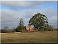
Young's Farm
A late C16 three bay house with C17 2½ storey wing and C19 laundry wing. Seen from public bridleway Ockley 157 (also the drive to Young's Farm).
Image: © Hugh Craddock
Taken: 7 Feb 2009
0.05 miles
2
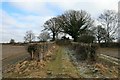
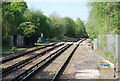
Ryersh Lane railway bridge (west ramp)
West ramp built to carry Ryersh Lane (public bridleway Ockley 157) over the Horsham-Dorking railway line.
Image: © Hugh Craddock
Taken: 7 Feb 2009
0.11 miles
3
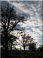
Field, trees and sky
Looking West towards the end of the day having crossed the railway and about to cross the A24 using a splendid bridleway.
Image: © Nick Warner
Taken: 22 Feb 2009
0.13 miles