IMAGES TAKEN NEAR TO
Claygate Road, DORKING, RH4 2PR
Introduction
This page details the photographs taken nearby to Claygate Road, RH4 2PR by members of the Geograph project.
The Geograph project started in 2005 with the aim of publishing, organising and preserving representative images for every square kilometre of Great Britain, Ireland and the Isle of Man.

There are currently over 7.5m images from over14,400 individuals and you can help contribute to the project by visiting https://www.geograph.org.uk
Image Map
Images are licensed for reuse under creativecommons.org/licenses/by-sa/2.0
Notes
- Clicking on the map will re-center to the selected point.
- The higher the marker number, the further away the image location is from the centre of the postcode.
Image Listing (49 Images Found)
Images are licensed for reuse under creativecommons.org/licenses/by-sa/2.0
Image
Details
Distance
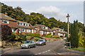
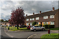
1
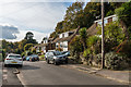
Claygate Road
Late 1950s/early 1960s housing built on the southern slopes of Tower Hill, on land previously belonging to Goodwyns Place.
Image: © Ian Capper
Taken: 21 Oct 2016
0.01 miles
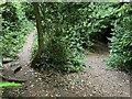
2
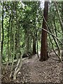
Devil's Den woods, Dorking
Footpath contouring around steep slope through Devil's Den woods, Dorking.
Image: © P Harris
Taken: 28 Jun 2024
0.05 miles
3
Martineau Drive, Dorking
View east from Martineau Drive, Dorking, with the Wenlock Edge and Linden Lea tower blocks of Goodwyns estate visible on the skyline.
Image: © P Harris
Taken: 21 Jun 2024
0.06 miles
4
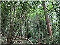
Devils Den woods, Dorking
Semi ancient woodland within Devils Den woods, Dorking.
Image: © P Harris
Taken: 28 Jun 2024
0.07 miles
5
Claygate Road
Late 1950s/early 1960s housing built on the southern slopes of Tower Hill, on land previously belonging to Goodwyns Place.
Image: © Ian Capper
Taken: 21 Oct 2016
0.08 miles
6
Devil's Den woods, Dorking
Fork in the path shortly after leaving Martineau Drive and entering Devil's Den woods.
Image: © P Harris
Taken: 28 Jun 2024
0.09 miles
7
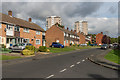
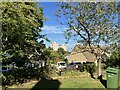
Oak Ridge
Housing in Oak Ridge on the Goodwyns Estate, a largely late 1950s housing estate built by Dorking Urban District Council on land compulsory purchased from local benefactor Howard Martineau, who until 1954 owned Goodwyns Place on Tower Hill, just to the north of the estate. In the background are the two tower blocks on the estate, Linden Lea and Wenlock Edge.
Image: © Ian Capper
Taken: 21 Oct 2016
0.09 miles
8
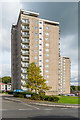
Linden Lea
One of two 120 foot 14 storey tower blocks on Stubs Hill on the Goodwyns Estate, built in 1964 for Dorking Urban District Council to a design of William W Ryder. Behind it on the right is part of the other block, Wenlock Edge. The estate was largely built in the late 1950s on land compulsory purchased from local benefactor Howard Martineau, who until 1954 owned Goodwyns Place on Tower Hill, just to the north of the estate.
Image: © Ian Capper
Taken: 21 Oct 2016
0.09 miles
9
Oak Ridge
Housing in Oak Ridge on the Goodwyns Estate, a largely late 1950s housing estate built by Dorking Urban District Council on land compulsory purchased from local benefactor Howard Martineau, who until 1954 owned Goodwyns Place on Tower Hill, just to the north of the estate.
Image: © Ian Capper
Taken: 21 Oct 2016
0.09 miles
10
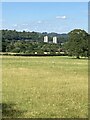
Linden Lea and Wenlock Edge
The Linden Lea and Wenlock Edge tower blocks on the Goodwyns Estate, as seen from about a mile south east near Redlands Wood.
Image: © P Harris
Taken: 18 Jul 2024
0.09 miles