IMAGES TAKEN NEAR TO
Calvert Road, DORKING, RH4 1LT
Introduction
This page details the photographs taken nearby to Calvert Road, RH4 1LT by members of the Geograph project.
The Geograph project started in 2005 with the aim of publishing, organising and preserving representative images for every square kilometre of Great Britain, Ireland and the Isle of Man.

There are currently over 7.5m images from over14,400 individuals and you can help contribute to the project by visiting https://www.geograph.org.uk
Image Map
Images are licensed for reuse under creativecommons.org/licenses/by-sa/2.0
Notes
- Clicking on the map will re-center to the selected point.
- The higher the marker number, the further away the image location is from the centre of the postcode.
Image Listing (132 Images Found)
Images are licensed for reuse under creativecommons.org/licenses/by-sa/2.0
Image
Details
Distance
1
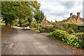
Keppel Road
1950s development on part of the Denbies Estate. The original plan had been to extend the road by extending it back on itself north of here, to run north of Yew Tree Road along the edge of what is known as Ten Acre Field, but this was blocked by the planners in 1954. The intended route is now a public footpath.
The name of the road presumably commemorates Sonia Keppel, who in 1920 had married Roland Cubitt, later to become 3rd Baron Ashcombe, whose family seat was Denbies. Camilla, Duchess of Cornwall, is their grandaughter.
Image: © Ian Capper
Taken: 10 Oct 2016
0.07 miles
2
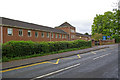
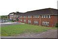
The Bradley Building, Ashcombe School
Ashcombe School was formed in 1976 from the amalgamation of the former Mowbray Secondary Modern School for Girls, founded in 1953, and the co-educational Dorking County Grammar School, founded in 1931 and itself an amalgamation of two other schools elsewhere in Dorking.
The Bradley Building, seen here, was the original home of the Mowbray School.
Image: © Ian Capper
Taken: 3 May 2010
0.08 miles
3
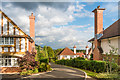
Calvert Gardens
Small upmarket development off Calvert Road, completed in 2014 on the site of the former Stanway School (New Lodge School from 2002 following merger with Nower Lodge School) which closed in 2007.
Image: © Ian Capper
Taken: 10 Oct 2016
0.09 miles
5
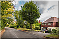
Keppel Road
1950s development on part of the Denbies Estate. The original plan had been to extend the road by extending it back on itself north of here, to run north of Yew Tree Road along the edge of what is known as Ten Acre Field, but this was blocked by the planners in 1954. The intended route is now a public footpath.
The name of the road presumably commemorates Sonia Keppel, who in 1920 had married Roland Cubitt, later to become 3rd Baron Ashcombe, whose family seat was Denbies. Camilla, Duchess of Cornwall, is their grandaughter.
Image: © Ian Capper
Taken: 10 Oct 2016
0.10 miles
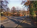
6
Ashcombe School
Sixth form college on the Ashcombe Road.
Website: http://www.ashcombe.surrey.sch.uk/
Image: © Paul Gillett
Taken: 19 Nov 2011
0.10 miles
7
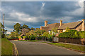
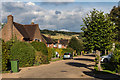
Calvert Road
Part of the Denbies Estate developed with upmarket housing in the late 1920s/early 1930s.
The name of the road presumably commemorates the surname by marriage of Beatrice Cubitt, daughter of George Cubitt, 1st Baron Ashcombe, whose family seat was Denbies. Beatrice married landowner and farmer William Calvert in 1891.
Image: © Ian Capper
Taken: 10 Oct 2016
0.11 miles
8
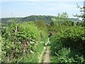
Mole Gap Trail
Looking towards Box Hill Image from the Mole Gap Trail, which first crosses Denbies Vineyard (See Image) then follows the boundary East.
Image: © Martyn Davies
Taken: 11 May 2006
0.11 miles
9
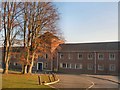
Ashcombe School
Ashcombe School was formed in 1976 from the amalgamation of the former Mowbray Secondary Modern School for Girls, founded in 1953, and the co-educational Dorking County Grammar School, founded in 1931 and itself an amalgamation of two other schools elsewhere in Dorking.
The Ranmore Building, at the far end of the ones seen here, was the original home of the Dorking Grammar School.
Image: © Ian Capper
Taken: 3 May 2010
0.12 miles
10
Croft Avenue
Cul-de-sac off London Road. The road is first shown on the 1914 25" map with three houses; by the 1935 6" map a few more had appeared, but it is not until the 1962 1:1250 map is it shown as being fully developed, as here.
In the background is Box Hill.
Image: © Ian Capper
Taken: 10 Oct 2016
0.13 miles