IMAGES TAKEN NEAR TO
Albert Road North, REIGATE, RH2 9EZ
Introduction
This page details the photographs taken nearby to Albert Road North, RH2 9EZ by members of the Geograph project.
The Geograph project started in 2005 with the aim of publishing, organising and preserving representative images for every square kilometre of Great Britain, Ireland and the Isle of Man.

There are currently over 7.5m images from over14,400 individuals and you can help contribute to the project by visiting https://www.geograph.org.uk
Image Map
Images are licensed for reuse under creativecommons.org/licenses/by-sa/2.0
Notes
- Clicking on the map will re-center to the selected point.
- The higher the marker number, the further away the image location is from the centre of the postcode.
Image Listing (256 Images Found)
Images are licensed for reuse under creativecommons.org/licenses/by-sa/2.0
Image
Details
Distance
1
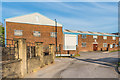
Stentor Music
Unit in Albert Road North Industrial Estate, a small industrial estate in a former sand quarry. Stentor manufactures and distributes stringed musical instruments for students.
Image: © Ian Capper
Taken: 21 Apr 2020
0.01 miles
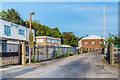
2
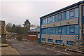
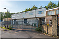
Albert Road North Industrial Estate
A small industrial estate built into what was once a sand quarry. it is not the ideal siting for one, access being through residential streets with on street parking (see Image for the immediate access route), and it has not been unknown for the area to be immobilised by a large HGV unable to manoeuvre round the corner by the Admiral Inn (see Image), because of parked cars.
Image: © Ian Capper
Taken: 20 Apr 2008
0.01 miles
4
Albert Road North Industrial Estate
A small industrial estate built into what was once a sand quarry. it is not the ideal siting for one, access being through Victorian residential streets with on street parking (see Image for the immediate access route), and it has not been unknown for the area to be immobilised by a large HGV unable to manoeuvre round the corner by the Admiral Inn (see Image), because of parked cars.
Image: © Ian Capper
Taken: 20 Apr 2008
0.04 miles
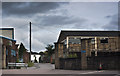
5
Albert Road North Industrial Estate
Small industrial estate in a former sand quarry.
Image: © Ian Capper
Taken: 21 Apr 2020
0.04 miles
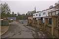
6
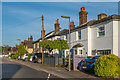
Albert Road North
Largely early 20th Century housing in Albert Road North. In the background is Churchfield Road, a 1990s development on the site of a former essence factory, and before that the photographic works of Francis Frith & Co. See Image for a closer view.
Image: © Ian Capper
Taken: 8 May 2020
0.05 miles
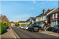
7
Albert Road North
Late Victorian housing built as part of the early development of north west Reigate. The 1895 Godfrey Edition map shows only the south side built at that stage - the north side, shown here presumably followed very soon after. In the distance, where the road joins Nutley Lane, can be seen the Admiral Inn (see Image).
Image: © Ian Capper
Taken: 20 Apr 2008
0.06 miles
8
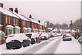
Albert Road North
Shown here after what is reputed to be the heaviest snow in the area for 18 years. See Image for further info and what it looks like without snow cover.
Image: © Ian Capper
Taken: 2 Feb 2009
0.06 miles
9
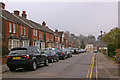
Albert Road North
Late Victorian housing - it is shown partly developed on the 1871-2 1:2,500 map, with the gaps shown as having been largely filled by the 1896 edition. In the former map it is shown as North Albert Road; by the time of the 1896 map it had been renamed with its present name, Albert Road North. The pair on the right of the photo, nos 41 - 43, served as the original Reigate Cottage Hospital from 1866 - 1871, one of the earliest cottage hospitals in the country.
Image: © Ian Capper
Taken: 21 Apr 2020
0.06 miles
10
Comtec House
Unit in Albert Road North Industrial Estate, a small industrial estate in a former sand quarry.
Image: © Ian Capper
Taken: 21 Apr 2020
0.06 miles