IMAGES TAKEN NEAR TO
Nutley Lane, REIGATE, RH2 9EF
Introduction
This page details the photographs taken nearby to Nutley Lane, RH2 9EF by members of the Geograph project.
The Geograph project started in 2005 with the aim of publishing, organising and preserving representative images for every square kilometre of Great Britain, Ireland and the Isle of Man.

There are currently over 7.5m images from over14,400 individuals and you can help contribute to the project by visiting https://www.geograph.org.uk
Image Map
Images are licensed for reuse under creativecommons.org/licenses/by-sa/2.0
Notes
- Clicking on the map will re-center to the selected point.
- The higher the marker number, the further away the image location is from the centre of the postcode.
Image Listing (330 Images Found)
Images are licensed for reuse under creativecommons.org/licenses/by-sa/2.0
Image
Details
Distance
1
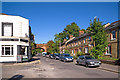
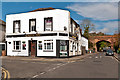
Nutley Lane
Looking up Nutley Lane by its junction with Albert Road North, with the Admiral pub on the left and the Reigate-Guildford railway bridge beyond.
Image: © Ian Capper
Taken: 10 Oct 2010
0.01 miles
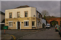
3
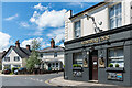
Admiral Inn
This pub stands at the junction of Albert Road North and Nutley Lane. The first records date from 1871. Beyond are 103 - 109 Nutley Lane, of the same era.
Image: © Ian Capper
Taken: 13 Jun 2020
0.01 miles
4
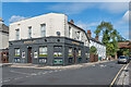
Admiral Inn
This pub stands at the junction of Albert Road North and Nutley Lane. The first records date from 1871. In the right background is the railway bridge carrying the Redhill - Guildford North Downs Line over Nutley Lane.
Image: © Ian Capper
Taken: 9 Oct 2020
0.01 miles
5
The Admiral Inn
This pub stands at the junction of Albert Road North and Nutley Lane. The first records date from 1871. In the background is the railway bridge carrying the Redhill - Guildford "North Downs Line", with the trees in the far distance being on the crest of the North Downs.
Compare Image, showing earlier paintwork.
Image: © Ian Capper
Taken: 2 Nov 2012
0.01 miles
6
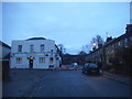
Go take a hike
No prior warning, the bridge has been closed. Luckily there is another one around the block.
Image: © David Howard
Taken: 17 Jan 2016
0.01 miles
7
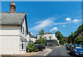
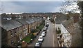
Nutley Lane
Looking north along Nutley Lane to the Admiral Inn and the bridge carrying the Redhill - Guildford North Downs Line over the road.
Image: © Ian Capper
Taken: 13 Jun 2020
0.02 miles
8
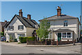
103-109 Nutley Lane
Victorian cottages in Nutley Lane. No 109, on the right, was until 2017 a corner shop (see Image).
Image: © Ian Capper
Taken: 7 May 2018
0.02 miles
9
The Admiral Inn
This pub stands at the junction of Albert Road North and Nutley Lane. The first records date from 1871. In the background is the railway bridge carrying the Redhill - Guildford "North Downs Line", with the trees in the far distance being on the crest of the North Downs.
Image: © Ian Capper
Taken: 10 Dec 2007
0.02 miles
10
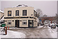
The Admiral Inn
Shown here after what is reputed to be the heaviest snow in the area for 18 years. See Image for further info and what it looks like without snow cover.
Image: © Ian Capper
Taken: 2 Feb 2009
0.02 miles