IMAGES TAKEN NEAR TO
Broadhurst Gardens, REIGATE, RH2 8AW
Introduction
This page details the photographs taken nearby to Broadhurst Gardens, RH2 8AW by members of the Geograph project.
The Geograph project started in 2005 with the aim of publishing, organising and preserving representative images for every square kilometre of Great Britain, Ireland and the Isle of Man.

There are currently over 7.5m images from over14,400 individuals and you can help contribute to the project by visiting https://www.geograph.org.uk
Image Map
Images are licensed for reuse under creativecommons.org/licenses/by-sa/2.0
Notes
- Clicking on the map will re-center to the selected point.
- The higher the marker number, the further away the image location is from the centre of the postcode.
Image Listing (74 Images Found)
Images are licensed for reuse under creativecommons.org/licenses/by-sa/2.0
Image
Details
Distance
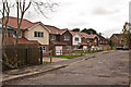
1
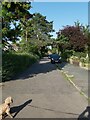
Street in Reigate
A view of Broadhurst Gardens, looking towards the A217, Cockshot Hill in the Woodhatch area of Reigate in Surrey.
Image: © John P Reeves
Taken: 17 Jul 2021
0.03 miles
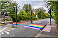
2
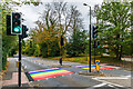
Cockshot Hill
Looking down Cockshot Hill. The rainbow stripes painted on the pelican crossing appeared the previous evening to when this photo was taken, under an initiative by Surrey County Council to have one such crossing in every borough/district in the county in support of Pride in Surrey. The choice of this particular crossing may have been influenced by the entrance to the left in this photo being to Surrey County Council's headquarters in what had previously been the offices of Canon UK (see Image).
Image: © Ian Capper
Taken: 28 Oct 2021
0.11 miles
3
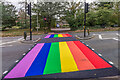
Rainbow crossing
Rainbow stripes painted on the pelican crossing on Cockshot Hill under an initiative by Surrey County Council to have one such crossing in every borough/district in the county in support of Pride in Surrey. The stripes had been painted the previous evening to when this photo was taken, hence their freshness.
Image: © Ian Capper
Taken: 28 Oct 2021
0.11 miles
4
Rainbow crossing
Rainbow stripes painted on the pelican crossing on Cockshot Hill under an initiative by Surrey County Council to have one such crossing in every borough/district in the county in support of Pride in Surrey. The stripes had been painted the previous evening to when this photo was taken, hence their freshness.
Image: © Ian Capper
Taken: 28 Oct 2021
0.11 miles
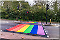
5
Cockshot Hill
Looking up Cockshot Hill. The rainbow stripes painted on the pelican crossing appeared the previous evening to when this photo was taken, under an initiative by Surrey County Council to have one such crossing in every borough/district in the county in support of Pride in Surrey.
Image: © Ian Capper
Taken: 28 Oct 2021
0.11 miles
6
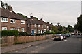
Alexander Road
1930s council housing in the South Park area of Reigate.
Image: © Ian Capper
Taken: 1 Sep 2012
0.11 miles
7
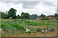
Riding School Allotments
Accessed off Prices Lane.
Image: © Robin Webster
Taken: 14 Jul 2010
0.12 miles
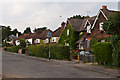
8
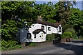
Primrose Cottage and Rose Cottage
Pair of late 18th century cottages on Cockshot Hill by its junction with Old Pottery Close. Locally listed.
Image: © Ian Capper
Taken: 26 May 2013
0.12 miles
9
Lime Close
New housing built in around 2010 on the site of St Michael's Church, a Roman Catholic Mass Centre built in the 1950s on the site of Woodhatch House and decommissioned in 2003. The close itself dates from around the same time (two of the original houses can be seen in the background).
Image: © Ian Capper
Taken: 6 Nov 2011
0.12 miles
10
Crescent Road
Crescent Road is shown on the 1896 1:2500 map, as part of the Victorian development of the South Park area, with the house on the right of this photo also being shown. Most of the other houses are later, dating from after the First World War.
Image: © Ian Capper
Taken: 1 Sep 2012
0.12 miles