IMAGES TAKEN NEAR TO
St. Marys Road, REIGATE, RH2 7JQ
Introduction
This page details the photographs taken nearby to St. Marys Road, RH2 7JQ by members of the Geograph project.
The Geograph project started in 2005 with the aim of publishing, organising and preserving representative images for every square kilometre of Great Britain, Ireland and the Isle of Man.

There are currently over 7.5m images from over14,400 individuals and you can help contribute to the project by visiting https://www.geograph.org.uk
Image Map
Images are licensed for reuse under creativecommons.org/licenses/by-sa/2.0
Notes
- Clicking on the map will re-center to the selected point.
- The higher the marker number, the further away the image location is from the centre of the postcode.
Image Listing (240 Images Found)
Images are licensed for reuse under creativecommons.org/licenses/by-sa/2.0
Image
Details
Distance
1
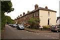
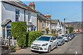
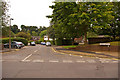
St Mary's Road
Late 19th/early 20th century terraced housing. On the right is Effingham Road (see Image).
Image: © Ian Capper
Taken: 26 Jul 2009
0.00 miles
2
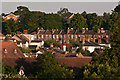
St Mary's Road
A terrace of houses in St Mary's Road, viewed across the rooftops from near the Town Hall. The newer blocks behind are in Orwell Gardens.
Image: © Ian Capper
Taken: 18 Jun 2012
0.01 miles
3
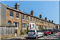
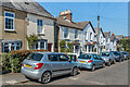
St Mary's Road
A Victorian terrace in St Mary's Road. The 1872 1:500 map shows this section of St Mary's Road as New Road (but without these houses, which are first shown on the 1896 map); the section further east was, however, called St Mary's Road from outset.
Image: © Ian Capper
Taken: 19 Apr 2021
0.01 miles
4
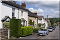
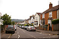
Effingham Road
1870s housing (the second pair of houses, Effingham Cottages, has a date plaque of 1878). In the background is Reigate Hill, topped by Reigate Hill TV transmitter.
Image: © Ian Capper
Taken: 25 May 2013
0.02 miles
5
Effingham Road
Victorian housing in Effingham Road. The pair of cottages in the centre of the photo has plaques reading Effingham Cottages and CRK 1878, with ones in the gables of the houses beyond reading MH 1870, EB 1869 and Laurel Cottage respectively.
Image: © Ian Capper
Taken: 19 Apr 2021
0.02 miles
6
Effingham Road
Victorian housing in Effingham Road. The nearest pair has plaques reading Effingham Cottages and CRK 1878, with ones in the gables of the houses to the right of the centre of the photo reading MH 1870, EB 1869 and Laurel Cottage respectively.
Image: © Ian Capper
Taken: 19 Apr 2021
0.03 miles
7
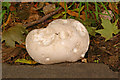
Giant Puffball (Calvatia gigantea)
Close-up of one of the examples in Image
Image: © Ian Capper
Taken: 26 Jul 2009
0.03 miles
8
Effingham Road
One of a pair of roads commemorating Howard of Effingham, Admiral of the Fleet that defeated the Spanish Armada in 1588, who lived in Reigate Priory and is buried in St Mary's Church. See Image In the background is Reigate Hill.
Image: © Ian Capper
Taken: 26 Jul 2009
0.03 miles
9
Lymden Gardens
Part of the 1960s or 70s Woodlands Estate (see Image). All the roads are named after vicars of St Mary's Church: in this photo is Lymden Gardens (named after John Lymden, vicar from 1532 to 1536 and the last prior of Reigate prior to the dissolution of Reigate Priory in the Reformation). The other roads on the estate are Harrison Close (named after John Harrison, vicar from 1847 to 1901), Talbot Close (named after Richard Talbot, vicar from 1929 to 1947), Sheldon Close (named after Frederick Sheldon, vicar from 1947 to 1957) and Cranston Close (named after Andrew Cranston, vicar from 1697 and 1708 and founder of the Cranston Library, the first public lending library in Britain - see Image).
Image: © Ian Capper
Taken: 26 Jul 2009
0.03 miles
10
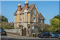
31 Howard Road
Large Victorian house in Howard Road by its junction with St Mary's Road, marked on the 1872 1:500 map.
Image: © Ian Capper
Taken: 19 Apr 2021
0.04 miles