IMAGES TAKEN NEAR TO
Chart Lane, REIGATE, RH2 7DY
Introduction
This page details the photographs taken nearby to Chart Lane, RH2 7DY by members of the Geograph project.
The Geograph project started in 2005 with the aim of publishing, organising and preserving representative images for every square kilometre of Great Britain, Ireland and the Isle of Man.

There are currently over 7.5m images from over14,400 individuals and you can help contribute to the project by visiting https://www.geograph.org.uk
Image Map
Images are licensed for reuse under creativecommons.org/licenses/by-sa/2.0
Notes
- Clicking on the map will re-center to the selected point.
- The higher the marker number, the further away the image location is from the centre of the postcode.
Image Listing (314 Images Found)
Images are licensed for reuse under creativecommons.org/licenses/by-sa/2.0
Image
Details
Distance
1
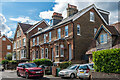
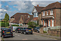
Chart Lane
Victorian terrace in Chart Lane - the plaque in the centre reads "Clayton Terrace 1888".
Image: © Ian Capper
Taken: 31 Aug 2020
0.01 miles
2
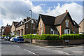
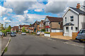
Chart Lane
Chart Lane where it is met by Glover's Road. The corner house, Chart Lodge (24 Chart Lane), dates from around 1860 and following years of deterioration has recently been restored, resulting in an award in 2011 by The Reigate Society.
Image: © Ian Capper
Taken: 15 Jun 2013
0.02 miles
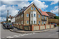
3
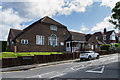
Reigate Ex-Service and Social Club
Private members' social club in Chartfield Road, the building itself dating from 1927.
Image: © Ian Capper
Taken: 15 Jun 2013
0.03 miles
4
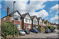
Chart Lane
Row of c.1910s/20s houses in Chart Lane, with no 33 nearest.
Image: © Ian Capper
Taken: 12 Apr 2021
0.03 miles
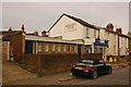
5
Chartfield Road
Houses in Chartfield Road, a road marked out in outline on the 1914 1:2,500 map, but with no houses shown. Beyond is the Reigate Ex-Service and Social Club (originally the Reigate ex-Service Men's Club, and now branded REXS), a building dating from the late 1920s.
Image: © Ian Capper
Taken: 31 Aug 2020
0.04 miles
6
2a Albion Road
Block of 8 flats on the corner of Albion Road and Chart Lane, competed in 2020. Previously the site was occupied by a small business unit, Group House.
Image: © Ian Capper
Taken: 12 Apr 2021
0.04 miles
7
Former Brethren Hall, Lesbourne Road
Former Brethren Hall, sold in 2008 and expected to be redeveloped.
Image: © Ian Capper
Taken: 26 Jul 2009
0.04 miles
8
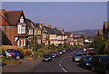
Chart Lane
Late Victorian housing.
Chart is a name that crops up in a number of places in Kent and Surrey, in the context of the lower greensand ridge that runs south of the North Downs, and Chart Lane, leading as it does over this ridge, would seem to fit in with this definition.
In the background are the North Downs to the west of Colley Hill. The office building in the middle distance is The Observatory (see Image).
Image: © Ian Capper
Taken: 21 Mar 2009
0.05 miles
9
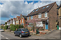
Chart Lane
c.1910s/20s houses in Chart Lane, with the semi-detached pair of nos 47 - 49 nearest.
Image: © Ian Capper
Taken: 12 Apr 2021
0.05 miles
10
Chartfield Road
Mainly c.1910s/20s houses in Chartfield Road, a road marked out in outline on the 1914 1:2,500 map, but with no houses shown. The house in the centre of the photo with black windows has a plaque "TJ 1925".
Image: © Ian Capper
Taken: 31 Aug 2020
0.06 miles