IMAGES TAKEN NEAR TO
Reigate Road, REIGATE, RH2 0QZ
Introduction
This page details the photographs taken nearby to Reigate Road, RH2 0QZ by members of the Geograph project.
The Geograph project started in 2005 with the aim of publishing, organising and preserving representative images for every square kilometre of Great Britain, Ireland and the Isle of Man.

There are currently over 7.5m images from over14,400 individuals and you can help contribute to the project by visiting https://www.geograph.org.uk
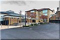
Image Map (Loading...)


Getting Data...Please wait
Leaflet Map data © OpenStreetMap
Images are licensed for reuse under creativecommons.org/licenses/by-sa/2.0
Notes
- Clicking on the map will re-center to the selected point.
- The higher the marker number, the further away the image location is from the centre of the postcode.
Image Listing (126 Images Found)
Images are licensed for reuse under creativecommons.org/licenses/by-sa/2.0
Image
Details
Distance
1
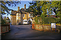
Eversfield
Eversfield is one of a number of large houses built in the late 1800s along the Reigate Road, many of which have now been demolished. Eversfield is now a care home, as was its neighbour Fonthill (situated behind the photographer) for many years (although now proposed for conversion to flats).
Image: © Ian Capper
Taken: 5 Jan 2008
0.04 miles
2
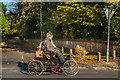
London to Brighton Veteran Car Run 2017 on Reigate Road
1901 Crest runabout registration no BS 8497 (start no 87) passing Ringley Park Road.
Image: © Ian Capper
Taken: 5 Nov 2017
0.05 miles
3
Reigate: Blackborough Close
Off the north side of Blackborough Road
Image: © Dr Neil Clifton
Taken: 18 Apr 2011
0.07 miles
4

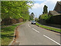
Ringley Park Road
Although the road itself existed in Victorian times, it was not built up until the 1950s/60s, with these houses built on the grounds of a large Victorian house called Ringley Oak, situated at the junction of Ringley Park Road and Reigate Road.
Image: © Ian Capper
Taken: 12 May 2012
0.07 miles
5
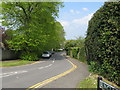
Reigate: Ringley Park Road
Looking north from Blackborough Road
Image: © Dr Neil Clifton
Taken: 18 Apr 2011
0.08 miles
6
Reigate Grammar School
Two Reigate Grammar School buildings - on the left the Peter Masefield Hall (named after a former chair of governors of the school) and in the centre the Ballance Building (opened in 2011 and named after Howard Ballance who was headmaster of the school from 1968 to 1982).
Image: © Ian Capper
Taken: 18 Jan 2021
0.10 miles
7
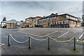
Reigate Grammar School
Three Reigate Grammar School buildings - on the left the Peter Masefield Hall (named after a former chair of governors of the school), in the centre the Ballance Building (opened in 2011 and named after Howard Ballance who was headmaster of the school from 1968 to 1982) and on the right the Science Block.
Image: © Ian Capper
Taken: 18 Jan 2021
0.10 miles
8
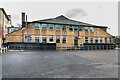
Reigate Grammar School
The Science Block at Reigate Grammar School.
Image: © Ian Capper
Taken: 18 Jan 2021
0.10 miles
9
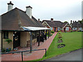
Victoria Almshouses
In Deerings Road. Built by public subscription as one of four projects approved by the Borough Council to celebrate the Diamond Jubilee of Queen Victoria in 1897. Work started in 1899, although the formal foundation stone was not laid until 18 April 1900. The first occupants moved in in late 1900. Further buildings on the site were added in 1911, various years in the 1920s and in 1939, with a major development being the addition of some flats in 1983.
See also Image for some further almshouses built by the same trust in Redhill in 1951.
Image: © Ian Capper
Taken: 4 May 2009
0.10 miles
10
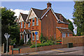
Deerings Road
House on the corner of Deerings Road and Reigate Road, built in 1899. For a close up of the stuccoed gable ends, see Image
Image: © Ian Capper
Taken: 25 Jul 2009
0.10 miles