IMAGES TAKEN NEAR TO
Beech Drive, REIGATE, RH2 0QU
Introduction
This page details the photographs taken nearby to Beech Drive, RH2 0QU by members of the Geograph project.
The Geograph project started in 2005 with the aim of publishing, organising and preserving representative images for every square kilometre of Great Britain, Ireland and the Isle of Man.

There are currently over 7.5m images from over14,400 individuals and you can help contribute to the project by visiting https://www.geograph.org.uk
Image Map
Images are licensed for reuse under creativecommons.org/licenses/by-sa/2.0
Notes
- Clicking on the map will re-center to the selected point.
- The higher the marker number, the further away the image location is from the centre of the postcode.
Image Listing (145 Images Found)
Images are licensed for reuse under creativecommons.org/licenses/by-sa/2.0
Image
Details
Distance
1
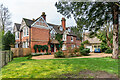
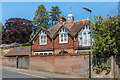
High Beeches and Little Beeches
Late Victorian house in Wray Common Road dating from 1891. Originally a single house named Friston, it is now in two sections, no 5 named High Beeches (on the left), now itself split into two flats and no 7 (on the right) named Little Beeches.
Image: © Ian Capper
Taken: 18 Jan 2021
0.04 miles
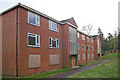
2
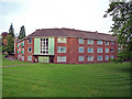
Harlow Court
1950s/1960s flats at the junction of Wray Common Road and Reigate Road.
Image: © Ian Capper
Taken: 4 May 2009
0.05 miles
3
The Cedars
Part of a small c.1960s mixed estate between Reigate Road and Wray Common Road, built on the site of four large late Victorian houses, Firlands and Grassmead on the former, Lowood (originally Low Wood) and West House on the latter.
Image: © Ian Capper
Taken: 15 May 2020
0.05 miles
4
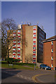
Fir Tree Walk
Block of flats operated by Mount Green Housing Association.
Image: © Ian Capper
Taken: 15 Mar 2009
0.06 miles
5
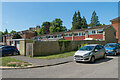
Wraymill Court
1950s/1960s flats, boarded up for ready for demolition and redevelopment.
Image: © Ian Capper
Taken: 13 Dec 2009
0.07 miles
6
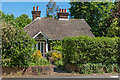
The Gatehouse
House in Wray Common Road, the former lodge to the adjacent Mill Lawn, a large house built in 1881.
Image: © Ian Capper
Taken: 15 May 2020
0.07 miles
7
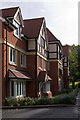
Baily Gardens
This development was completed in 2011 replacing a previous block called Wraymill Court (see Image). It was originally advertised as Wraymill Place, presumably reflecting the previous name.1618293
Image: © Ian Capper
Taken: 9 Oct 2011
0.07 miles
8
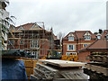
Building site, Redhill
Baily Gardens, a redevelopment off Wray Common Road.
Image: © Robin Webster
Taken: 17 Nov 2010
0.07 miles
9
Mill Lawn Stables
House in Wray Common Road, the former stables/coach house to the nearby Mill Lawn, a large house built in 1881.
Image: © Ian Capper
Taken: 15 May 2020
0.07 miles
10
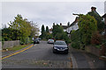
Millway
The road name refers to Blackborough Mill, whose site was at the top end of this close. The mill, a post mill, was built around 1736, but had fallen into disuse by 1900 and was demolished in 1936.
Millway first appears on maps in the early 20th century.
Image: © Ian Capper
Taken: 9 Oct 2011
0.07 miles