IMAGES TAKEN NEAR TO
Doods Place, Doods Road, REIGATE, RH2 0NS
Introduction
This page details the photographs taken nearby to Doods Place, Doods Road, RH2 0NS by members of the Geograph project.
The Geograph project started in 2005 with the aim of publishing, organising and preserving representative images for every square kilometre of Great Britain, Ireland and the Isle of Man.

There are currently over 7.5m images from over14,400 individuals and you can help contribute to the project by visiting https://www.geograph.org.uk
Image Map (Loading...)


Getting Data...Please wait
Leaflet Map data © OpenStreetMap
Images are licensed for reuse under creativecommons.org/licenses/by-sa/2.0
Notes
- Clicking on the map will re-center to the selected point.
- The higher the marker number, the further away the image location is from the centre of the postcode.
Image Listing (102 Images Found)
Images are licensed for reuse under creativecommons.org/licenses/by-sa/2.0
Image
Details
Distance
1
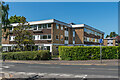
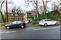
Doods Place
1960s apartment blocks at the junction of Doods Road and Wray Common Road, built on the site of Little Doods Farm, later known simply as Doods.
Image: © Ian Capper
Taken: 15 May 2020
0.02 miles
2
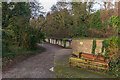
Garages, Dorchester Court
A row of garages serving Dorchester Court, a c.1960s block of flats in a former sand quarry off Wray Common Road. The garages are situated on the site of a former siding connecting the quarry to the Redhill - Reigate railway.
Image: © Ian Capper
Taken: 18 Jan 2021
0.03 miles
3
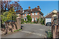
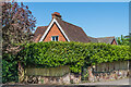
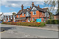
92 - 94 Doods Road
Large neo-Georgian house built in 1903 (with the date inscribed on the rainwater-heads at the top of the downpipes), now split into two residences, no 92 (part hidden on the left of the photo) and no 94 (the main part visible in the photo). The architect was Horace Field. It appears to have had various names over the years: older maps show no name, whereas the 1961-2 1:1,250 map (which shows the house split into two) names no 92 as Cedars and no 94 as Hetherwood (and given that the map also marks a nearby lodge as Hetherwood Lodge (see Image), this suggests that this may have originally been the name for the whole building). The 1968-70 edition retains the name Cedars for no 92 but only shows a house number for no 94. However, the entrance to no 92 now has a name plate "Field House" (presumably in recognition of the architect) and various online references remain to no 94 being named Hetherwood.
Image: © Ian Capper
Taken: 15 May 2020
0.04 miles
4
Dorchester Court
c.1960s block of flats in a former sand quarry off Wray Common Road. Because of its situation, the main access is towards the top of the building, as seen here.
Image: © Ian Capper
Taken: 18 Jan 2021
0.04 miles
5

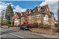
Rosemount House, 90A Doods Road
Large building completed in 2015, containing 3 houses and built in Queen Anne style to fit in with its immediate neighbour, built around 100 years earlier but of similar style.
Image: © Ian Capper
Taken: 15 May 2020
0.04 miles
6
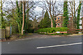
Hetherwood Lodge
1860s lodge at the junction of Doods Road and Wray Common Road, possibly originally serving a house in Doods Road called Lexden House (since demolished), and later included in the grounds of Hetherwood, now nos 92 - 94 Doods Road (see Image).
Image: © Ian Capper
Taken: 15 May 2020
0.04 miles
7
Dorchester Court
c.1960s block of flats in a former sand quarry off Wray Common Road. Because of its situation, the main access is towards the top of the building, although the driveway seen here leads to the floor of the quarry and the base of the building.
Image: © Ian Capper
Taken: 18 Jan 2021
0.05 miles
8
Rosehill
Block of 11 flats on the corner of Doods Way and Wray Common Road completed in 2006, replacing a large early 20th Century house of the same name.
Image: © Ian Capper
Taken: 19 May 2020
0.05 miles
9
Rosehill
Block of 11 flats on the corner of Doods Way and Wray Common Road completed in 2006, replacing a large early 20th Century house of the same name.
Image: © Ian Capper
Taken: 12 Apr 2021
0.05 miles
10
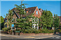
Wray Common Nursing Home
Nursing home on Wray Common Road, the core of which is a large late Victorian house named Woodthorpe.
Image: © Ian Capper
Taken: 12 Apr 2021
0.05 miles