IMAGES TAKEN NEAR TO
Batts Hill, REIGATE, RH2 0LJ
Introduction
This page details the photographs taken nearby to Batts Hill, RH2 0LJ by members of the Geograph project.
The Geograph project started in 2005 with the aim of publishing, organising and preserving representative images for every square kilometre of Great Britain, Ireland and the Isle of Man.

There are currently over 7.5m images from over14,400 individuals and you can help contribute to the project by visiting https://www.geograph.org.uk
Image Map
Images are licensed for reuse under creativecommons.org/licenses/by-sa/2.0
Notes
- Clicking on the map will re-center to the selected point.
- The higher the marker number, the further away the image location is from the centre of the postcode.
Image Listing (60 Images Found)
Images are licensed for reuse under creativecommons.org/licenses/by-sa/2.0
Image
Details
Distance
1
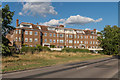
Wray Mill House
Large apartment block completed in the 1990s, overlooking Wray Common.
Image: © Ian Capper
Taken: 3 Aug 2014
0.01 miles
2
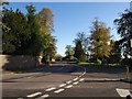
Batts Hill, Redhill
At the junction with Coniston Way (right).
Image: © Derek Harper
Taken: 15 Oct 2011
0.04 miles
3
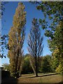
Wray Common
Poplars, ashes and other trees in the easternmost corner of the common, near Batts Hill.
Image: © Derek Harper
Taken: 15 Oct 2011
0.05 miles
4
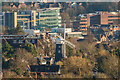
Wray Common Windmill
A telephoto view of Wray Common Windmill (see Image) from the slopes of Reigate Hill, with office blocks in central Redhill in the background, RedCentral and Kingsgate on the left (see Image) and Bridge Gate on the right (see Image).
Image: © Ian Capper
Taken: 15 Jan 2016
0.07 miles
5

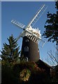
The Windmill
The windmill off Wray Common
Image: © Kurseong Carl
Taken: 4 Jul 2010
0.07 miles
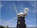
6
Wray Common Windmill
A particularly photogenic windmill, with its black tarred brick contrasting with the white sails. See also images at http://www.geograph.org.uk/search.php?i=25802946 , and http://www.britishlistedbuildings.co.uk/en-289262-wray-common-windmill-66-reigate .
Image: © Derek Harper
Taken: 15 Oct 2011
0.07 miles
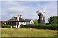
7
Wray Common Windmill
This view of the windmill shown in http://www.geograph.org.uk/search.php?i=25802792 is across a small pond on the common. The windmill is described at http://www.britishlistedbuildings.co.uk/en-289262-wray-common-windmill-66-reigate .
Image: © Derek Harper
Taken: 15 Oct 2011
0.07 miles
8

Wray Common Windmill
A distant view of Wray Common Windmill (see Image) from the former Betchworth Quarry. The large wooded area in front of the windmill hides the houses of north west Reigate.
Image: © Ian Capper
Taken: 30 Jun 2012
0.07 miles
9
Wray Common Windmill
Wray Common Windmill near Reigate.
Image: © Roy Henderson
Taken: 14 Aug 2011
0.07 miles
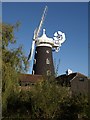
10
Wray Common Windmill and Wray Mill Cottages
Wray Common Windmill is a tower mill originally built in 1824 - although not on an obvious hill when viewed from nearby, it is in fact quite prominent when viewed from the east, being clearly visible from the M23 around 3 miles away. It stopped working in 1895. It was first converted to a dwelling in 1966/7, but its condition subsequently deteriorated. A new renovation was carried out from 2004 - 2006, winning an award as "best conversion" in the Daily Telegraph Homebuilding and Renovating Awards 2006. The sails are dummies, added as part of the recent renovation - prior to that the mill was sailless for many years.
Image: © Ian Capper
Taken: 17 Jul 2010
0.07 miles