IMAGES TAKEN NEAR TO
The Way, REIGATE, RH2 0LD
Introduction
This page details the photographs taken nearby to The Way, RH2 0LD by members of the Geograph project.
The Geograph project started in 2005 with the aim of publishing, organising and preserving representative images for every square kilometre of Great Britain, Ireland and the Isle of Man.

There are currently over 7.5m images from over14,400 individuals and you can help contribute to the project by visiting https://www.geograph.org.uk
Image Map
Images are licensed for reuse under creativecommons.org/licenses/by-sa/2.0
Notes
- Clicking on the map will re-center to the selected point.
- The higher the marker number, the further away the image location is from the centre of the postcode.
Image Listing (106 Images Found)
Images are licensed for reuse under creativecommons.org/licenses/by-sa/2.0
Image
Details
Distance
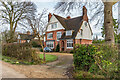
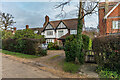
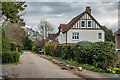
3
The Way
Cul-de-sac connecting Doods Way with Wray Common. Although originally laid out in the late 19th Century, the initial development was only on the eastern side, with a row of large Edwardian houses. The development of the western side, as seen here, was much later.
Image: © Ian Capper
Taken: 15 May 2020
0.03 miles
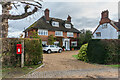
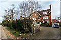
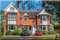
4
The Way
This road appears on the 1871 1:2500 map as part of Oaks Road, linking Croydon Road and Doods Road. The Oaks was a large house on the northern section of the road, with the wall visible here (not the house behind, which was much more recent) looking to be original.
By the 1896 map, the two sections of the road had been separated, as now, with this southern section renamed The Way.
By 1914 the eastern side (left in this photo) had been developed, with the western side (on the right, including the house seen here) being developed by the early 1960s.
Image: © Ian Capper
Taken: 15 Jun 2013
0.04 miles
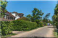
7
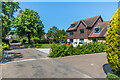
Highlands Road
Cul-de-sac off Wray Common Road originally laid out in the c.1930s using part of the land of a large Victorian house named Highlands (since extended and used as offices and named Johnston House). The house seen here, 1 Highlands Road, is an early 2010s enlargement of the original building dating from the c.1960s/70s.
Image: © Ian Capper
Taken: 15 May 2020
0.09 miles
8
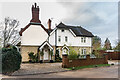
Sandcliff
Edwardian house in Doods Way. The name presumably refers to the former sand quarry behind it.
Image: © Ian Capper
Taken: 18 Jan 2021
0.11 miles
9
Highlands
Edwardian house in Doods Way, named "The Dyke" on older maps.
Image: © Ian Capper
Taken: 12 Apr 2021
0.11 miles
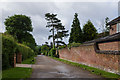
10
Carr End
Large house in Doods Way designed by local architect Albert Venner, dating from 1885.
Image: © Ian Capper
Taken: 15 May 2020
0.11 miles