IMAGES TAKEN NEAR TO
Wray Lane, REIGATE, RH2 0HS
Introduction
This page details the photographs taken nearby to Wray Lane, RH2 0HS by members of the Geograph project.
The Geograph project started in 2005 with the aim of publishing, organising and preserving representative images for every square kilometre of Great Britain, Ireland and the Isle of Man.

There are currently over 7.5m images from over14,400 individuals and you can help contribute to the project by visiting https://www.geograph.org.uk
Image Map
Images are licensed for reuse under creativecommons.org/licenses/by-sa/2.0
Notes
- Clicking on the map will re-center to the selected point.
- The higher the marker number, the further away the image location is from the centre of the postcode.
Image Listing (77 Images Found)
Images are licensed for reuse under creativecommons.org/licenses/by-sa/2.0
Image
Details
Distance
1
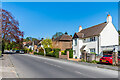
Wray Lane
Mid 20th Century housing in Wray Lane.
Image: © Ian Capper
Taken: 13 Apr 2020
0.02 miles
2

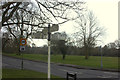
View from slopes of Reigate Hill
Looking towards Redhill - for telephoto shot of the central area, see Image
Image: © Ian Capper
Taken: 24 Jan 2009
0.04 miles
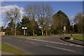
4
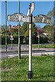
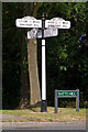
Signpost
This mid 19th Century cast iron road sign is on Wray Common, Reigate, at the junction of Croydon Road, Batts Hill and Wray Lane.
Image: © Ian Capper
Taken: 13 Apr 2020
0.08 miles
5
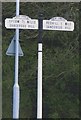
19th Century road sign
This mid 19th Century cast iron road sign is on Wray Common, Reigate, at the junction of Croydon Road, Batts Hill (the "dangerous hill" to Redhill) and Wray Lane (the "dangerous hill" to Epsom - now used as a cut through to junction 8 on the M25). See Image for a picture of the junction.
Image: © Ian Capper
Taken: 1 Mar 2008
0.08 miles
6
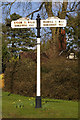
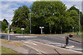
19th Century road sign
This mid 19th Century cast iron road sign is on Wray Common, Reigate, at the junction of Croydon Road, Batts Hill (the "dangerous hill" to Redhill) and Wray Lane (the "dangerous hill" to Epsom - now used as a cut through to junction 8 on the M25). Compare Image - the sign has now been fully restored with all four arms.
See Image for a picture of the junction.
Image: © Ian Capper
Taken: 17 Jul 2010
0.08 miles
7
Old Direction Sign - Signpost by the A242, Wray Common
Pawn finial - 4 arms; Surrey arch name arms by the A242, in parish of Reigate (Reigate And Banstead District), Wray Common, Gatton Park Road junction with Batts Hill, Croydon Road and Wray Lane, on verge by roundabout (arm was broken in 2009 - restored back to 4 arms by 2012).
Surveyed
Milestone Society National ID: SY_TQ2651
Image: © John V Nicholls
Taken: Unknown
0.08 miles
8
Junction of Croydon Road and Batts Hill
Image: © Ian Capper
Taken: 17 Jul 2010
0.08 miles
9
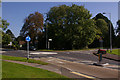
Junction of Croydon Road and Batts Hill
Compare Image During the summer of 2008 a roundabout was installed at this junction. Note the signpost (see Image for previous closeup) - the northern arm was apparently clipped by a lorry. Fortunately it was found, dumped in a nearby ditch, and the intention is to restore it, along with the western arm which has been in storage for years.
Image: © Ian Capper
Taken: 27 Sep 2008
0.08 miles
10
Junction of Croydon Road and Batts Hill
This picture contains two interesting 19th century artefacts - a road sign (see Image) and a cattle trough (see Image).
Image: © Ian Capper
Taken: 1 Mar 2008
0.08 miles