IMAGES TAKEN NEAR TO
Alma Road, REIGATE, RH2 0EN
Introduction
This page details the photographs taken nearby to Alma Road, RH2 0EN by members of the Geograph project.
The Geograph project started in 2005 with the aim of publishing, organising and preserving representative images for every square kilometre of Great Britain, Ireland and the Isle of Man.

There are currently over 7.5m images from over14,400 individuals and you can help contribute to the project by visiting https://www.geograph.org.uk
Image Map
Images are licensed for reuse under creativecommons.org/licenses/by-sa/2.0
Notes
- Clicking on the map will re-center to the selected point.
- The higher the marker number, the further away the image location is from the centre of the postcode.
Image Listing (300 Images Found)
Images are licensed for reuse under creativecommons.org/licenses/by-sa/2.0
Image
Details
Distance
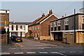
1
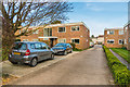
Langley Court
Low rise flats off Alma Road.
Image: © Ian Capper
Taken: 7 Apr 2020
0.00 miles
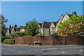
2
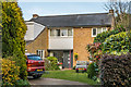
7 Alma Road
1953 house in Alma Road designed by Leslie Gooday, Wycliffe Noble and Donald Pierce of the architects Gooday and Noble. At first sight and ordinary house, except that it is specifically referred to in the Pevsener guide "The Buildings of England - Surrey", by Ian Nairn and Nikolaus Pevsner (revised by Bridget Cherry) in which it is described as "A familiar type, but nicely detailed and landscaped. Pitched slate roof, one band of vertical cedar bonding on the front, and the open treads of staircase seen behind a window beside the door - a cliché as effective as the c18 house with its central Venetian window at the back to light the half landing". The reference to a vertical band suggests it has since been altered. One wonders whether it would have appeared in the book had it not been directly opposite St Mark's Church, and so would have been seen when viewing that building.
Image: © Ian Capper
Taken: 7 Apr 2020
0.01 miles
3
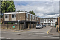
Birkheads Road
A short stub of Birkheads Road to the east of Alma Road (in the foreground). The offices on the left are on the site of what the 1896 1:2,500 map marks as a "lecture room", but shown on the 1963 1:2,500 map as St Mark's Church Hall.
Image: © Ian Capper
Taken: 28 Jun 2020
0.03 miles
4
Birkheads Road
A short stub of Birkheads Road to the east of Alma Road (in the foreground). The offices on the left are on the site of what the 1896 1:2,500 map marks as a "lecture room", but shown on the 1963 1:2,500 map as St Mark's Church Hall.
Image: © Ian Capper
Taken: 3 Aug 2014
0.03 miles
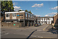
5
Birkheads Road
A short stub of Birkheads Road to the east of Alma Road (in the foreground). Maps suggest that the terrace of cottages date from the very end of the 19th/start of the 20th century. These have survived, whereas other buildings at the time, including what is marked on the 1896 1:2,500 map as a "lecture room", but shown on the 1963 1:2,500 map as St Mark's Church Hall, where the building on the far left of the photo now stands, have all been replaced by offices.
Image: © Ian Capper
Taken: 23 May 2012
0.03 miles
6
St Marks and St Marys
Two Reigate churches, as seen from the slopes of Colley Hill. The lower of the two is St Mark's (see Image) with St Mary's (see Image) beyond.
Image: © Ian Capper
Taken: 31 Jul 2011
0.03 miles
7
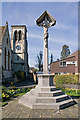
War Memorial, Alma Road
Alongside St Marks Church in Alma Road, the tower of which can be seen in the background. Unusually, it was originally unveiled in November 1917, a year before the end of the First World War.
Image: © Ian Capper
Taken: 19 Mar 2011
0.04 miles
8
Birkheads Road
1860 locally listed villas built in Reigate Stone to a design of Field and Hilton, who also designed St Marks Church, whose roofline is just visible on the right of the photo, in the same year.
Image: © Ian Capper
Taken: 9 May 2009
0.04 miles
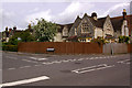
9
3 - 11 Birkheads Road and 4 Alma Road
Row of houses dating from 1860 and designed by the London architects Sidney Field and John Hilton, who were also responsible for the nearby St Mark's Church of the same year. Locally listed.
Image: © Ian Capper
Taken: 13 Apr 2020
0.04 miles
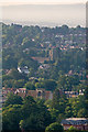
10
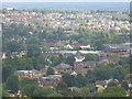
Reigate from Colley Hill
Historic market town at the foot of the North Downs. Today it is very much a dormitory town for Gatwick and London commuters.
Image: © Colin Smith
Taken: 10 Jul 2011
0.04 miles