
IMAGES TAKEN NEAR TO
Alma Road, REIGATE, RH2 0AX
Introduction
This page details the photographs taken nearby to Alma Road, RH2 0AX by members of the Geograph project.
The Geograph project started in 2005 with the aim of publishing, organising and preserving representative images for every square kilometre of Great Britain, Ireland and the Isle of Man.

There are currently over 7.5m images from over14,400 individuals and you can help contribute to the project by visiting https://www.geograph.org.uk
Image Map
Images are licensed for reuse under creativecommons.org/licenses/by-sa/2.0
Notes
- Clicking on the map will re-center to the selected point.
- The higher the marker number, the further away the image location is from the centre of the postcode.
Image Listing (335 Images Found)
Images are licensed for reuse under creativecommons.org/licenses/by-sa/2.0
Image
Details
Distance
1
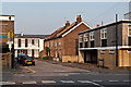
Birkheads Road
A short stub of Birkheads Road to the east of Alma Road (in the foreground). Maps suggest that the terrace of cottages date from the very end of the 19th/start of the 20th century. These have survived, whereas other buildings at the time, including what is marked on the 1896 1:2,500 map as a "lecture room", but shown on the 1963 1:2,500 map as St Mark's Church Hall, where the building on the far left of the photo now stands, have all been replaced by offices.
Image: © Ian Capper
Taken: 23 May 2012
0.01 miles
2
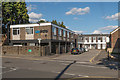
Birkheads Road
A short stub of Birkheads Road to the east of Alma Road (in the foreground). The offices on the left are on the site of what the 1896 1:2,500 map marks as a "lecture room", but shown on the 1963 1:2,500 map as St Mark's Church Hall.
Image: © Ian Capper
Taken: 3 Aug 2014
0.01 miles
3
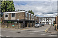
Birkheads Road
A short stub of Birkheads Road to the east of Alma Road (in the foreground). The offices on the left are on the site of what the 1896 1:2,500 map marks as a "lecture room", but shown on the 1963 1:2,500 map as St Mark's Church Hall.
Image: © Ian Capper
Taken: 28 Jun 2020
0.02 miles
4
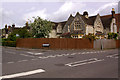
Birkheads Road
1860 locally listed villas built in Reigate Stone to a design of Field and Hilton, who also designed St Marks Church, whose roofline is just visible on the right of the photo, in the same year.
Image: © Ian Capper
Taken: 9 May 2009
0.03 miles
5
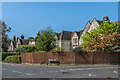
3 - 11 Birkheads Road and 4 Alma Road
Row of houses dating from 1860 and designed by the London architects Sidney Field and John Hilton, who were also responsible for the nearby St Mark's Church of the same year. Locally listed.
Image: © Ian Capper
Taken: 13 Apr 2020
0.03 miles
6
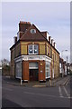
Devonshire House
Victorian building situated at the junction of Warren Road with Holmesdale Road, now used for offices.
Image: © Ian Capper
Taken: 24 Jan 2009
0.03 miles
7
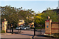
Wanmer Court
Apartment blocks built around 1995 between Birkheads Road and Holmesdale Road.
Image: © Ian Capper
Taken: 27 May 2012
0.03 miles
8
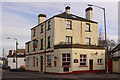
The Prince of Wales
Shown as a pub in the 1895 Godfrey Edition map of Reigate. For close up of pub sign, see Image
Image: © Ian Capper
Taken: 24 Jan 2009
0.03 miles
9
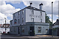
The Prince of Wales
Newly repainted Prince of Wales - compare Image
Image: © Ian Capper
Taken: 7 Sep 2013
0.03 miles
10
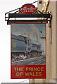
The Prince of Wales - pub sign
See Image At first glance, why should a picture of a former Great Central Railway steam locomotive be shown on a pub here, albeit one situated by a station, but a station very much in Southern territory? Further investigation shows that 62662, a D11 "Improved Director" class locomotive, built in March 1920 and originally numbered 505, was named "Prince of Wales". So the pub sign is not totally irrelevant, even if geographically flawed.
Image: © Ian Capper
Taken: 24 Jan 2009
0.03 miles