IMAGES TAKEN NEAR TO
John Ireland Way, PULBOROUGH, RH20 4EP
Introduction
This page details the photographs taken nearby to John Ireland Way, RH20 4EP by members of the Geograph project.
The Geograph project started in 2005 with the aim of publishing, organising and preserving representative images for every square kilometre of Great Britain, Ireland and the Isle of Man.

There are currently over 7.5m images from over14,400 individuals and you can help contribute to the project by visiting https://www.geograph.org.uk
Image Map (Loading...)


Getting Data...Please wait
Leaflet Map data © OpenStreetMap
Images are licensed for reuse under creativecommons.org/licenses/by-sa/2.0
Notes
- Clicking on the map will re-center to the selected point.
- The higher the marker number, the further away the image location is from the centre of the postcode.
Image Listing (15 Images Found)
Images are licensed for reuse under creativecommons.org/licenses/by-sa/2.0
Image
Details
Distance
1
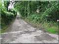
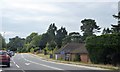
Hampers Lane narrows to a single track road
Image: © Dave Spicer
Taken: 1 Aug 2009
0.08 miles
2
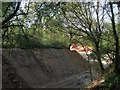
Sandgate Quarry
Looking into the entrance from Hampers Lane and looking towards a big pile of sand which is quarried here. Much of the current quarry was originally the grounds of Sandgate Park whose last inhabitant died in 1946 whereupon the land was purchased for quarrying which it still is today.
Image: © Simon Carey
Taken: 6 May 2013
0.10 miles
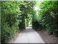
3
Hampers Lane and former entrance to disused sandpit on the left
Hampers Lane is also a bridleway north to the B2139
Image: © Dave Spicer
Taken: 1 Aug 2009
0.11 miles
4
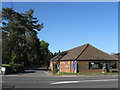
Clayton Kennels
On Storrington Road and occupying outbuildings belonging to the former Clayton Farm.
Image: © Simon Carey
Taken: 6 May 2013
0.12 miles
5
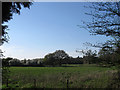
Filly's Heath/Long Meadow
The name of the field according to Sullington's 1840 tithe map. Filly's Heath was in the foreground and was once a recreation ground but no longer seems the case. Long Meadow is the long, thin piece of land beyond the tree to the right.
Image: © Simon Carey
Taken: 6 May 2013
0.13 miles
6
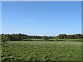
The Fifteen Acres
The name of the field according to Washington's 1839 tithe map viewed from Storrington Road, the A283. Beyond the hedge in the distance is Image with the houses of Image partially obscured by the tree.
Image: © Simon Carey
Taken: 6 May 2013
0.14 miles
8
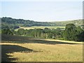
South Downs above Barns Farm, viewed from the field north of Claytons Farm on A283 and west of Georges Lane
Picture taken from top right corner of the field north of Claytons Farm on A283 between Washington and Storrington, looking Southwest. The A283 is hidden by trees. The South Downs Way runs along the top centre portion of the hills in this photograph.
Image: © S Chilcott
Taken: 8 Jul 2006
0.19 miles
9

Sandy Lane
A private road with houses on the left and a worked-out and overgrown sandpit on the right.
Image: © Robin Webster
Taken: 27 May 2011
0.20 miles