IMAGES TAKEN NEAR TO
Storrington Road, PULBOROUGH, RH20 4AG
Introduction
This page details the photographs taken nearby to Storrington Road, RH20 4AG by members of the Geograph project.
The Geograph project started in 2005 with the aim of publishing, organising and preserving representative images for every square kilometre of Great Britain, Ireland and the Isle of Man.

There are currently over 7.5m images from over14,400 individuals and you can help contribute to the project by visiting https://www.geograph.org.uk
Image Map
Images are licensed for reuse under creativecommons.org/licenses/by-sa/2.0
Notes
- Clicking on the map will re-center to the selected point.
- The higher the marker number, the further away the image location is from the centre of the postcode.
Image Listing (18 Images Found)
Images are licensed for reuse under creativecommons.org/licenses/by-sa/2.0
Image
Details
Distance
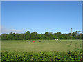
1
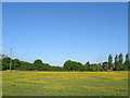
The Ox Marsh (2)
Three weeks on from Image and the field has a carpet of buttercups and a couple of campers all of whom were out playing football at about 8am on a bank holiday Monday morning.
Image: © Simon Carey
Taken: 27 May 2013
0.08 miles
2
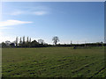
The Ox Marsh
The name of the field according to Washington's 1839 tithe map viewed from the drive to Rowdell House. Part of the old field has been lost to the house called Woodman's just visible on the left.
Image: © Simon Carey
Taken: 6 May 2013
0.08 miles
3
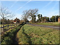
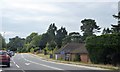
A283 west to Storrington
Rockford Lodge with a pentagonal porch is on the left.
Image: © Dave Spicer
Taken: 2 Jan 2011
0.10 miles
4
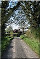
Rowdell Lodge
Built in the early 19th century next to the junction of the drive to Rowdell house and Storrington Road, currently the A283.
Image: © Simon Carey
Taken: 6 May 2013
0.13 miles
5
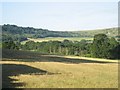
South Downs above Barns Farm, viewed from the field north of Claytons Farm on A283 and west of Georges Lane
Picture taken from top right corner of the field north of Claytons Farm on A283 between Washington and Storrington, looking Southwest. The A283 is hidden by trees. The South Downs Way runs along the top centre portion of the hills in this photograph.
Image: © S Chilcott
Taken: 8 Jul 2006
0.14 miles
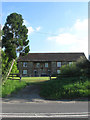
6
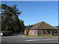
Clayton Kennels
On Storrington Road and occupying outbuildings belonging to the former Clayton Farm.
Image: © Simon Carey
Taken: 6 May 2013
0.14 miles
8
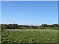
The Fifteen Acres
The name of the field according to Washington's 1839 tithe map viewed from Storrington Road, the A283. Beyond the hedge in the distance is Image with the houses of Image partially obscured by the tree.
Image: © Simon Carey
Taken: 6 May 2013
0.15 miles
9
Bradbury Court
Formerly East Clayton Farm, the farmhouse, barns and other outbuildings were converted by owners, the National Trust, into semi-independent units for the seriously disabled and opened in 2009. Storrington Road, the A283, lies in the foreground.
Image: © Simon Carey
Taken: 27 May 2013
0.15 miles
10
The Costicles/Inner Costicles
The name of the fields according to Washington's 1839 tithe map that have been joined together to make a larger unit. The Costicle was next to the bridleway whilst the Inner Costicles was adjacent to the small wood which was named as Rowdell Wood on the same tithe map though is nameless on OS maps.
Image: © Simon Carey
Taken: 27 May 2013
0.15 miles