IMAGES TAKEN NEAR TO
Posthorses, PULBOROUGH, RH20 3QF
Introduction
This page details the photographs taken nearby to Posthorses, RH20 3QF by members of the Geograph project.
The Geograph project started in 2005 with the aim of publishing, organising and preserving representative images for every square kilometre of Great Britain, Ireland and the Isle of Man.

There are currently over 7.5m images from over14,400 individuals and you can help contribute to the project by visiting https://www.geograph.org.uk
Image Map
Images are licensed for reuse under creativecommons.org/licenses/by-sa/2.0
Notes
- Clicking on the map will re-center to the selected point.
- The higher the marker number, the further away the image location is from the centre of the postcode.
Image Listing (80 Images Found)
Images are licensed for reuse under creativecommons.org/licenses/by-sa/2.0
Image
Details
Distance
1
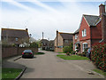
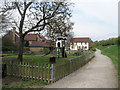
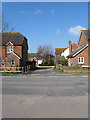
Posthorses
The name of the cul de sac that lies off London Road, the former A24. The close was built after the bypass opened as the land between the former and latter courses of the A24 were developed. The name derives from the nearby former Swan Inn, the first major staging post on the Worthing to London turnpike.
Image: © Simon Carey
Taken: 28 Apr 2013
0.02 miles
2
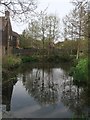
Pond, Ashington
Lying to the immediate west of Image the pond was in existence long before the housing estate arrived. The three ducks on the water had floated over hopeful for food but left disappointed.
Image: © Simon Carey
Taken: 28 Apr 2013
0.03 miles
3
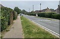
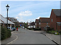
London Road
London Road in Ashington near Church Lane looking northwards.
Image: © Chris Thomas-Atkin
Taken: 5 Sep 2021
0.04 miles
4
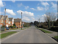
London Road
The straight nature of the road is due to its course being marked out when the former Ashington Common, which it crossed, was enclosed in 1816. From that enclosure comes the origins of the modern village of Ashington which eventually built itself up around it, despite this part actually being in the parish of Washington until 1960. An important route in the age of coaching it retained this during the age of the motor car becoming the A24 which for many years was clogged by traffic until the construction of the bypass in the mid 1990s finally bought peace to the centre of the village. The houses on the left are Forge House, The Smithy and Anvil House built on the site of the former village blacksmith. The older dwellings beyond are Blacksmiths Cottages.
Image: © Simon Carey
Taken: 2 Apr 2013
0.04 miles
5
Playground, Ashington
Added as part of the development of the land between London Road, the old course of the A24 and the bypass opened in 1996, which lies beyond the embankment to the right. A public path has also been provided running from the footbridge to Swan House
Image: © Simon Carey
Taken: 28 Apr 2013
0.05 miles
7
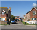
Turnpike Way
A cul de sac off London Road built when the new bypass to the east was constructed allowing the former farmland between to be developed into housing. London Road was the former Worthing-London turnpike.
Image: © Simon Carey
Taken: 28 Apr 2013
0.08 miles
8
Ashdene Gardens
A small cul de sac off london Road built around the turn of the century on the site of an old nursery.
Image: © Simon Carey
Taken: 2 Apr 2013
0.08 miles
9
Blacksmiths Close
A small cul de sac off London Road built on the site of an old filling station during the 1990s. Named after the former village blacksmiths which was once located nearby.
Image: © Simon Carey
Taken: 2 Apr 2013
0.08 miles
10
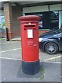
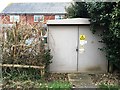
Post Box
Post Box RH20 20 Ashington. Ashington Post Office.
Image: © The Saunterer
Taken: 12 May 2012
0.08 miles