IMAGES TAKEN NEAR TO
Meiros Way, PULBOROUGH, RH20 3QB
Introduction
This page details the photographs taken nearby to Meiros Way, RH20 3QB by members of the Geograph project.
The Geograph project started in 2005 with the aim of publishing, organising and preserving representative images for every square kilometre of Great Britain, Ireland and the Isle of Man.

There are currently over 7.5m images from over14,400 individuals and you can help contribute to the project by visiting https://www.geograph.org.uk
Image Map (Loading...)


Getting Data...Please wait
Leaflet Map data © OpenStreetMap
Images are licensed for reuse under creativecommons.org/licenses/by-sa/2.0
Notes
- Clicking on the map will re-center to the selected point.
- The higher the marker number, the further away the image location is from the centre of the postcode.
Image Listing (37 Images Found)
Images are licensed for reuse under creativecommons.org/licenses/by-sa/2.0
Image
Details
Distance
1
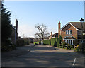
Meiros Way
Built on the site of former fields belonging to neighbouring Meiros Farm which itself has recently been developed, see Image
Image: © Simon Carey
Taken: 2 Apr 2013
0.04 miles
2
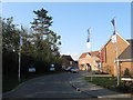
Blakiston Close
A recently built close off Rectory Lane constructed on the grounds of what was Meiros Farm which itself was once the rectory for Ashington. The former Victorian farmhouse has been converted into a new home as part of the development.
Image: © Simon Carey
Taken: 2 Apr 2013
0.05 miles
3
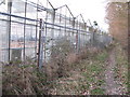
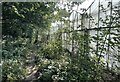
Obsolete greenhouses
Situated on the west side of Ashington.
Image: © Dave Spicer
Taken: 28 Feb 2009
0.07 miles
4
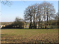
Dorman Meadow
The name of the field according to Ashington's 1847 tithe map that lies in a narrow strip alongside the northern edge of Rectory Lane.
Image: © Simon Carey
Taken: 2 Apr 2013
0.08 miles
5

Chanctonbury Playschool
Chanctonbury Playschool on Rectory Lane
Image: © The Saunterer
Taken: 12 May 2012
0.08 miles
6
Footpath beside Nursery
On footpath number 2607 as it passes the greenhouses of a Nursery on the outskirts of Ashington.
Image: © Chris Thomas-Atkin
Taken: 5 Sep 2021
0.11 miles
7
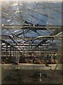
Disused Nursery
Viewed through a broken pane in one of the glasshouses from the footpath that links Foster Lane to Rectory Lane. The nursery seems to have closed for a while so in all probability it will be developed into a small housing estate sometime in the future.
Image: © Simon Carey
Taken: 2 Apr 2013
0.11 miles
8
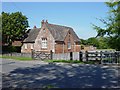
The Old School, Ashington
Looking north. Built in 1872.
Image: © Janine Forbes
Taken: 31 Aug 2005
0.11 miles
9
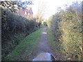
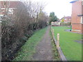
Path between Drain and Hedge
Public footpath 2606 to Rectory Lane.
Image: © Peter Holmes
Taken: 8 Feb 2014
0.11 miles
10
Path behind The Sands
Public footpath 2606 to Rectory Lane.
Image: © Peter Holmes
Taken: 8 Feb 2014
0.12 miles