IMAGES TAKEN NEAR TO
Brookside, PULBOROUGH, RH20 3BD
Introduction
This page details the photographs taken nearby to Brookside, RH20 3BD by members of the Geograph project.
The Geograph project started in 2005 with the aim of publishing, organising and preserving representative images for every square kilometre of Great Britain, Ireland and the Isle of Man.

There are currently over 7.5m images from over14,400 individuals and you can help contribute to the project by visiting https://www.geograph.org.uk
Image Map
Images are licensed for reuse under creativecommons.org/licenses/by-sa/2.0
Notes
- Clicking on the map will re-center to the selected point.
- The higher the marker number, the further away the image location is from the centre of the postcode.
Image Listing (74 Images Found)
Images are licensed for reuse under creativecommons.org/licenses/by-sa/2.0
Image
Details
Distance
1
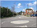
Mill Lane
Viewed from its junction with London Road, like the latter it was laid out when the common was enclosed to enable access from the new road to the older dwellings and mill which lay outside the boundaries of the old common. To the right is Image which was built in the late 18th century prior to enclosure and taking advantage of the growth of coaching traffic between London and the newly developed resort of Worthing.
Image: © Simon Carey
Taken: 2 Apr 2013
0.03 miles
2
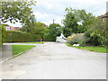
Looking east on Mill Lane
A view from the previous year is at http://www.geograph.org.uk/photo/3859585.
Image: © Shazz
Taken: 4 Sep 2015
0.04 miles
3
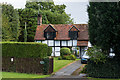
The Willows
17th Century cottage in Willow Way. Grade II listed - see https://www.historicengland.org.uk/listing/the-list/list-entry/1027159.
Image: © Ian Capper
Taken: 30 Sep 2016
0.04 miles
4
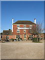
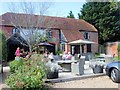
The Red Lion
Originally built towards the end of the 18th century on an isolated pocket of land on Ashington Common. When the latter was enclosed in 1816 it faced out onto the newly marked out and turnpiked London Road whereupon it became an important stopping point for coaches. Its former stables, out of shot to the right, are now an extension to the inn.
Image: © Simon Carey
Taken: 31 Mar 2013
0.04 miles
5
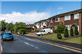
Mill Lane
1970s housing in what is shown on the 1974 1:2500 map as Red Lion Lane.
Image: © Ian Capper
Taken: 30 Sep 2016
0.04 miles
7
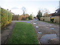
Mill Lane
Public footpath 2613 to London Road.
Image: © Peter Holmes
Taken: 8 Feb 2014
0.05 miles
9
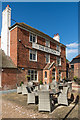
The Red Lion
18th Century grade II listed inn - see https://www.historicengland.org.uk/listing/the-list/list-entry/1354091.
Image: © Ian Capper
Taken: 30 Sep 2016
0.06 miles
10
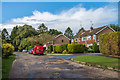
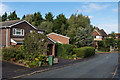
Mill Lane
1960s/70s housing. The 1974 1:2500 map calls this section of road Fairfield Road, a name that now only applies to the road off to the right in this photo.
Image: © Ian Capper
Taken: 30 Sep 2016
0.06 miles