IMAGES TAKEN NEAR TO
Hadworth Lane, PULBOROUGH, RH20 1PG
Introduction
This page details the photographs taken nearby to Hadworth Lane, RH20 1PG by members of the Geograph project.
The Geograph project started in 2005 with the aim of publishing, organising and preserving representative images for every square kilometre of Great Britain, Ireland and the Isle of Man.

There are currently over 7.5m images from over14,400 individuals and you can help contribute to the project by visiting https://www.geograph.org.uk
Image Map
Images are licensed for reuse under creativecommons.org/licenses/by-sa/2.0
Notes
- Clicking on the map will re-center to the selected point.
- The higher the marker number, the further away the image location is from the centre of the postcode.
Image Listing (12 Images Found)
Images are licensed for reuse under creativecommons.org/licenses/by-sa/2.0
Image
Details
Distance

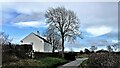
2
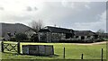
Hadworth Farmhouse
Bignor Hill can be seen in the background.
Image: © Ian Hawfinch
Taken: 11 Mar 2021
0.02 miles
3
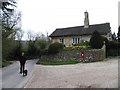
Upper House in West Burton West Sussex
En route to the Roman Villa, this village has some very timber frame houses. This house though is newer and situated in the far south eastern section of the grid square. The picture was taken looking north.
Image: © Pam Brophy
Taken: 17 Apr 2005
0.15 miles
4
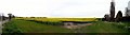
Rapeseed Farmland
Situated between West Burton and the Roman Villa, this picture was taken from the north side of the road looking north and west of Hadworth Farm.
Image: © Pam Brophy
Taken: 17 Apr 2005
0.15 miles
5

Sunflower head
There was a field of immensely tall sunflowers to the north of the public footpath.
Image: © Ian Hawfinch
Taken: 7 Oct 2022
0.16 miles
6
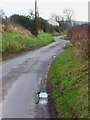
The road to West Burton from Bignor
The cottage is also seen at http://www.geograph.org.uk/photo/2270033.
Image: © Shazz
Taken: 4 Jan 2013
0.18 miles
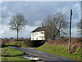
7
Newhouse - on the road between Bignor and West Burton
Image: © Ian Hawfinch
Taken: 11 Mar 2021
0.18 miles
8
Corner cottage, Bignor
On the corner of the way to Hadworth Farm, and presumably formerly farm cottages. Neither place appears to be involved in agriculture anymore.
Image: © Robin Webster
Taken: 14 Feb 2011
0.19 miles
9

Newhouse seen across fields from the south
My earlier picture of the cottage from the west is at http://www.geograph.org.uk/photo/3282131.
Image: © Shazz
Taken: 18 Jan 2014
0.19 miles
10
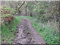
Bend in bridleway
The spot where I'm standing is where the old roman road Stane Street turned slightly to the NE
Image: © Dave Spicer
Taken: 11 Apr 2009
0.22 miles