IMAGES TAKEN NEAR TO
Worsted Lane, EAST GRINSTEAD, RH19 3UF
Introduction
This page details the photographs taken nearby to Worsted Lane, RH19 3UF by members of the Geograph project.
The Geograph project started in 2005 with the aim of publishing, organising and preserving representative images for every square kilometre of Great Britain, Ireland and the Isle of Man.

There are currently over 7.5m images from over14,400 individuals and you can help contribute to the project by visiting https://www.geograph.org.uk
Image Map
Images are licensed for reuse under creativecommons.org/licenses/by-sa/2.0
Notes
- Clicking on the map will re-center to the selected point.
- The higher the marker number, the further away the image location is from the centre of the postcode.
Image Listing (20 Images Found)
Images are licensed for reuse under creativecommons.org/licenses/by-sa/2.0
Image
Details
Distance
1
Bench Fields Acre Plat
The name of the field according to East Grinstead's 1841 tithe map that is located to the south west of Worsted Farm.
Image: © Simon Carey
Taken: 7 Apr 2021
0.03 miles
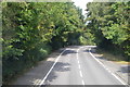
2
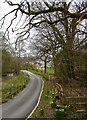
Worsted Lane East Grinstead
The lane services a few houses and continues as the bridleway to Fowl Wood and onto Homestall Road.
Image: © Dave Spicer
Taken: 24 Oct 2012
0.06 miles
3
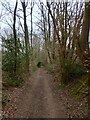
Shovelstrode Lane
An old track that once linked Shovelstrode Farm to East Grinstead that has now been reduced in status to that of a bridleway. To the north of the farm the lane becomes metalled and heads towards the A264.
Image: © Simon Carey
Taken: 7 Apr 2021
0.08 miles
4
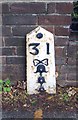
Old Milestone by the A22, Lewes Road, East Grinstead
Metal plate attached to concrete post by the A22, in parish of East Grinstead (Mid Sussex District), South side of town, before boundary, past Woodbury, by the road, on North East side of road. Bow Bells iron plate, erected by the Surrey & Sussex turnpike trust in the 19th century.
Inscription reads:-
31
{Bow and 4 Bells}
Milestone Society National ID: SX_LL31
Image: © A Rosevear
Taken: Unknown
0.09 miles
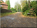
5
Drive to Worsted Farm
The farm is just visible in the distance whilst the drive itself is showing signs of spring.
Image: © Simon Carey
Taken: 7 Apr 2021
0.09 miles
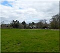
6
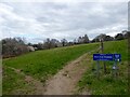
Farm Close Meadows
A couple of fields on the edge of the town that is now open access. On East Grinstead's 1841 tithe map it was the northern portion of Turnpike Field the southern part now containing houses and their gardens.
Image: © Simon Carey
Taken: 7 Apr 2021
0.12 miles
8
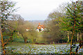
A glimpse of Worsted Farm
Soon this view will be obscured by Leylandii planted along the bridleway fenceline.
Image: © Robin Webster
Taken: 21 Jan 2010
0.13 miles
9
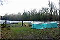
Hay for the horses?
This field had a sign about not feeding the horses, among other things, but no horses were to be seen today.
Image: © Robin Webster
Taken: 21 Jan 2010
0.14 miles