IMAGES TAKEN NEAR TO
Bramble Twitten, EAST GRINSTEAD, RH19 3DX
Introduction
This page details the photographs taken nearby to Bramble Twitten, RH19 3DX by members of the Geograph project.
The Geograph project started in 2005 with the aim of publishing, organising and preserving representative images for every square kilometre of Great Britain, Ireland and the Isle of Man.

There are currently over 7.5m images from over14,400 individuals and you can help contribute to the project by visiting https://www.geograph.org.uk
Image Map
Images are licensed for reuse under creativecommons.org/licenses/by-sa/2.0
Notes
- Clicking on the map will re-center to the selected point.
- The higher the marker number, the further away the image location is from the centre of the postcode.
Image Listing (20 Images Found)
Images are licensed for reuse under creativecommons.org/licenses/by-sa/2.0
Image
Details
Distance
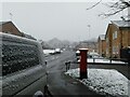
1
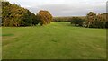
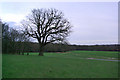
East Court Playing Fields
Taken from the slope below the main East Court Buildings.
Image: © Barry Hunter
Taken: 9 Sep 2024
0.13 miles
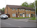
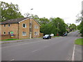
3
Sports pavilion near East Court
Daylight fading fast on a gloomy evening.
Image: © Robin Webster
Taken: 17 Jan 2007
0.16 miles
7
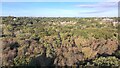
Above the Trees of Ashplats Wood
360 degree pano taken above the tree canopy (30m above ground) of show East Grinstead looking very green.
Image: © Barry Hunter
Taken: 17 Sep 2024
0.17 miles
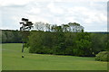
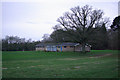
9
East Court playing fields, East Grinstead
Ashplatts Wood is beyond.
Image: © Robin Webster
Taken: 17 Jan 2007
0.17 miles
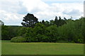
10
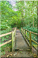
Footbridge, Ashplats Wood
Footbridge over a stream in Ashplats Wood, whose water eventually joins the River Medway near Hartfield.
Image: © Ian Capper
Taken: 26 Sep 2023
0.18 miles