IMAGES TAKEN NEAR TO
Perry Avenue, EAST GRINSTEAD, RH19 2DJ
Introduction
This page details the photographs taken nearby to Perry Avenue, RH19 2DJ by members of the Geograph project.
The Geograph project started in 2005 with the aim of publishing, organising and preserving representative images for every square kilometre of Great Britain, Ireland and the Isle of Man.

There are currently over 7.5m images from over14,400 individuals and you can help contribute to the project by visiting https://www.geograph.org.uk
Image Map
Images are licensed for reuse under creativecommons.org/licenses/by-sa/2.0
Notes
- Clicking on the map will re-center to the selected point.
- The higher the marker number, the further away the image location is from the centre of the postcode.
Image Listing (60 Images Found)
Images are licensed for reuse under creativecommons.org/licenses/by-sa/2.0
Image
Details
Distance
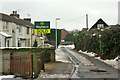
1
Alders Avenue is closed
The road has been dug up to provide utilities connections to new houses.
Image: © Robin Webster
Taken: 26 Feb 2020
0.07 miles
2
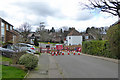
Alders Avenue is closed
The road has been dug up to provide utilities connections to new houses that have been squeezed in at the right.
Image: © Robin Webster
Taken: 26 Feb 2020
0.08 miles
3
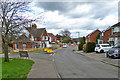
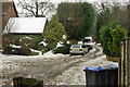
Alders Avenue, East Grinstead
Alders Avenue is a residential road in the town of East Grinstead, in West Sussex.
Image: © Malc McDonald
Taken: 14 Dec 2019
0.09 miles
4
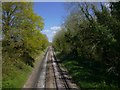
Looking north along railway from Hackenden Lane bridge
Image: © Shazz
Taken: 4 May 2016
0.10 miles
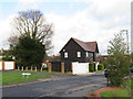
5
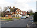
Hermitage Road, East Grinstead
Alders Avenue is at the end.
Image: © Robin Webster
Taken: 15 Jan 2010
0.11 miles
6
Alders Avenue, East Grinstead
Alders Avenue is a residential road in the town of East Grinstead, in West Sussex.
Image: © Malc McDonald
Taken: 14 Dec 2019
0.11 miles
7
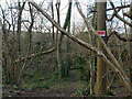
Private woodland by Hackenden Lane
Only a narrow strip between the lane and the railway. There is something down below which is not a tree. On old maps a small gasworks was here, so probably there are remains. It is likely that this supplied the former convent, orphanage and school of St Margaret's.
Image: © Robin Webster
Taken: 12 Mar 2022
0.12 miles
8
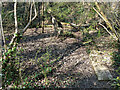
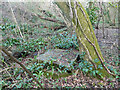
Remains of a building north of Hackenden Lane
L-shaped, as far as could be seen, concrete away from the camera and at the far side at least partly brick towards the left. I was looking for any trace of the gas works that was once mapped here, but may have got the exact spot wrong. The map shows a line fitting this which looks like the bounds of a level area, the tanks and building being shown further left. Nothing was obvious, apart from a concrete well-like structure with a heavy concrete slab on top - see Image
Image: © Robin Webster
Taken: 23 Mar 2022
0.12 miles
9
Covered well or drain north of Hackenden Lane
A vertical concrete pipe, crudely closed with a heavy concrete slab. I was looking for any trace of the gas works that was once mapped here, but may have got the exact spot wrong. This looks more like a drainage installation than anything gassy.
Image: © Robin Webster
Taken: 23 Mar 2022
0.12 miles
10
South end of Eden Vale, East Grinstead
Looking from the footpath through to Alders Avenue.
Image: © Robin Webster
Taken: 15 Jan 2010
0.12 miles